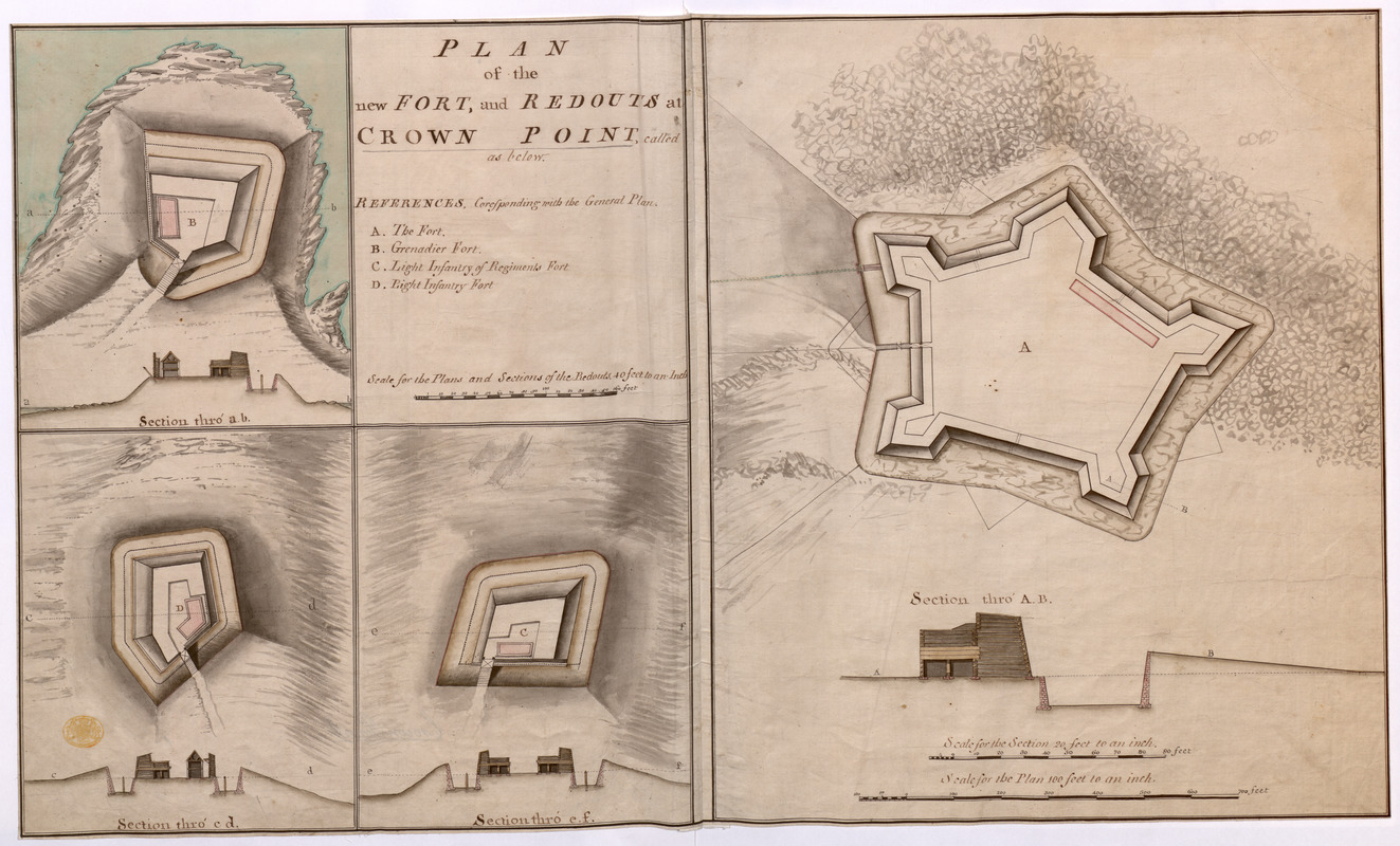
PLAN of the new FORT, and REDOUTS at CROWN POINT, called as below
This map is also available in American Revolutionary Geographies Online (ARGO), a collections portal especially built for material relating to the American Revolutionary War Era. Visit ARGO to learn more about this item and explore the historical geography of North America in the late eighteenth century.
Item Information
- Title:
- PLAN of the new FORT, and REDOUTS at CROWN POINT, called as below
- Former owner:
- George, III, King of Great Britain, 1738-1820
- Donor:
- George, IV, King of Great Britain, 1762-1830
- Date:
-
1759
- Format:
-
Maps/Atlases
Manuscripts
- Location:
- British Library
- Collection (local):
-
British Library Collection
- Subjects:
-
Fortification--New York (State)--Crown Point--Maps, Manuscript--Early works to 1800
Military art and science--New York (State)--Crown Point--Maps, Manuscript--Early works to 1800
Crown Point (N.Y.)--Maps, Manuscript--Early works to 1800
United States--History--French and Indian War, 1754-1763--Maps, Manuscript--Early works to 1800
- Places:
-
Essex (county)Crown Point (cape)
- Extent:
- 4 maps on 1 sheet : manuscript pen and ink with watercolour ; sheet 44 x 73 cm
- Terms of Use:
-
No known copyright restrictions.
This work is licensed for use under a Creative Commons Attribution Non-Commercial Share Alike License (CC BY-NC-SA).

- Scale:
-
Scale 1:1,200
- Language:
-
English
- Catalog Record:
-
http://explore.bl.uk/BLVU1:LSCOP-ALL:BLL01004987786
- Notes:
-
A date of about 1759 is attributed based on other dated maps in the King's Topographical Collection (see Maps K.Top.121.52.) illustrating the fort's construction.
A composite sheet with the right half comprising the map of the fort with a cross sectional illustration below. The left half of the sheet is quartered to show the title and three further maps of the "Grenadier Fort", the "Light Infantry of Regiments Fort" and the "Light Infantry Fort".
The scale for the fort is given as "Scale for the Plan 100 feet to an inch".
The scale for the cross section is given as "Scale for the Section 20 feet to an inch" (1:240).
The "Scale for the Plans and Sections of the Redouts, 40 feet to an Inch" (1:480) is given within the title.
Consider John Montèsor as cartographer? Compare his later (signed) map of the fort - Maps K.Top.121.54.
This manuscript map could be the source for a printed map of Crown Point Fort which appeared in "A SET of PLANS and FORTS IN AMERICA, Reduced from Actual Surveys", first published in 1763. A copy of the second edition of the work published by Mary Ann Rocque (1765) may be found in the King's Topographical Collection (118.a.22.). Plate 23 (in the second edition) is that of Crown Point, while plate 25 is that of the Grenadier Fort", the "Light Infantry of Regiments Fort" and the "Light Infantry Fort". Letters from Mary Ann Rocque to Lord Bute, who advised George III's early collecting, are known to exist in the Mount Stuart archives (Peter Barber - Head of Cartographic and Topographic Materials at the British Library).
Titled "A drawn Plan of the new Fort and Redoubts at Crown Point" in the Catalogue of Maps, Prints, Drawings, etc., forming the geographical and topographical collection attached to the Library of his late Majesty King George the third, etc., London, 1829.
Titled 'A colored "plan of the new Fort and Redoubts at Crown Point;" the fort drawn on a scale of 100 feet to an inch, with section on a scale of 20 feet to an inch; the plans and sectiosn of the redoubts, viz. Grenadier fort, Light Infantry of Regiments fort, and Light Infantry fort, on a scale of 40 feet to an inch: 2 f. 5 in. x 1 f. 5 in.' in the Catalogue of the manuscript maps, charts, and plans, and of the topographical drawings in the British Museum.