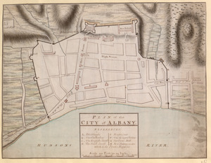
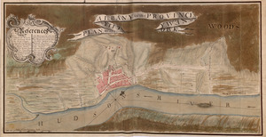
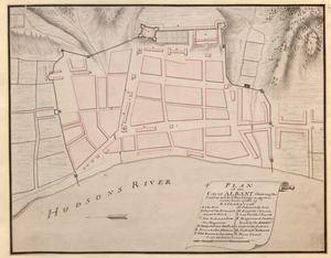
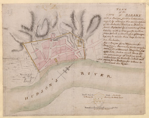
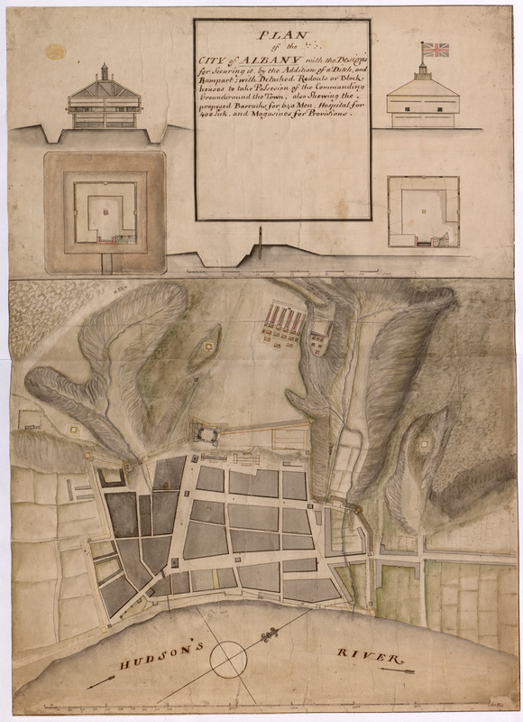
PLAN of the CITY of ALBANY with the Designs for Securing it by the Addition of a Ditch, and Rampart; with Detached Redouts or Block houses to take Possesion of the Commanding Grounds round the Town, also Shewing the proposed Barracks for 640 Men, Hospital for 400 Sick, and Magasines for Provisions
This map is also available in American Revolutionary Geographies Online (ARGO), a collections portal especially built for material relating to the American Revolutionary War Era. Visit ARGO to learn more about this item and explore the historical geography of North America in the late eighteenth century.
Item Information
- Title:
- PLAN of the CITY of ALBANY with the Designs for Securing it by the Addition of a Ditch, and Rampart; with Detached Redouts or Block houses to take Possesion of the Commanding Grounds round the Town, also Shewing the proposed Barracks for 640 Men, Hospital for 400 Sick, and Magasines for Provisions
- Former owner:
- George, III, King of Great Britain, 1738-1820
- Donor:
- George, IV, King of Great Britain, 1762-1830
- Date:
-
1756
- Format:
-
Maps/Atlases
Manuscripts
- Location:
- British Library
- Collection (local):
-
British Library Collection
- Subjects:
-
Fortification--New York (State)--Albany--Maps, Manuscript--Early works to 1800
Military art and science--New York (State)--Albany--Maps, Manuscript--Early works to 1800
Albany (N.Y.)--Maps, Manuscript--Early works to 1800
Fort Albany (N.Y.)--Maps, Manuscript--Early works to 1800
United States--History--French and Indian War, 1754-1763--Maps, Manuscript--Early works to 1800
- Places:
-
Albany (county)Albany
Fort Frederick (historical)
- Extent:
- 1 map : manuscript pen and ink with watercolour ; 74 x 53 cm
- Terms of Use:
-
No known copyright restrictions.
This work is licensed for use under a Creative Commons Attribution Non-Commercial Share Alike License (CC BY-NC-SA).

- Scale:
-
Scale approximately 1:2,400
- Language:
-
English
- Catalog Record:
-
http://explore.bl.uk/BLVU1:LSCOP-ALL:BLL01004987675
- Notes:
-
Shows a date of 1756 to the verso.
Relief is shown by shading.
Shows a scale across the lower edge of the map where 200 feet are equal to one inch.
Shows five inset plans, profiles and sections of the fort and defences at the top of the page with their own scale of 110 feet equal to 7 8/10 inches (approximately 1:170).
Shows a compass in the Hudson River identifying north on the map.
Titled "A drawn Plan of the City of Albany, with the designs for securing it, 1756" in the Catalogue of Maps, Prints, Drawings, etc., forming the geographical and topographical collection attached to the Library of his late Majesty King George the third, etc., London, 1829.
Titled 'A colored "plan of the city of Albany, with the designs for securing it, by the addition of a ditch and rampart; with detached redoubts or blockhouses to take possession of the commanding grounds round the town; also shewing the proposed barracks for 640 men, hospital for 400 sick, and magazines for provisions;' drawn in 1756, on a scale of 200 feet to an inch; with plans and profils of the redoubts, on a scale of 14 feet to an inch; 2 f. 5 in. x 1 f. 9 in.' in the Catalogue of the manuscript maps, charts, and plans, and of the topographical drawings in the British Museum.