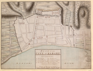
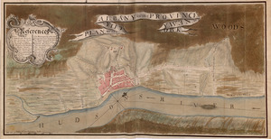
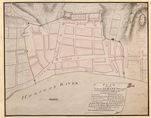
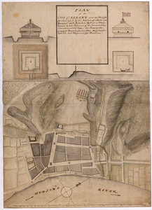
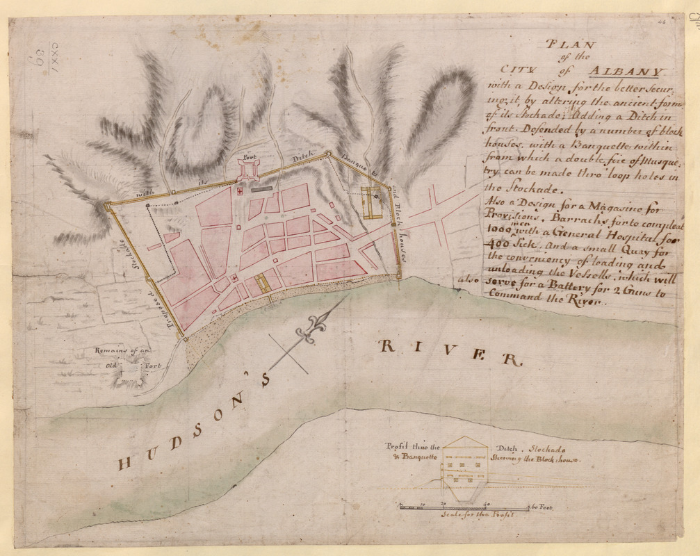
PLAN of the CITY of ALBANY with a Design for the better securing it, by altering the ancient form of its Stockade; Adding a Ditch in fron Defended by a number of block houses, with a Banquette within from which a double fire of Musquetry can be made thro' loop holes in the Stockade. Also a Design for a Magasine for provisions, Barracks for to compleat 1000 men with a General Hospital for 400 Sick, and a small Quay for the conveniency of loading and unloading the Vessells, which will also serve for a Battery for 2 Guns to Command the River
This map is also available in American Revolutionary Geographies Online (ARGO), a collections portal especially built for material relating to the American Revolutionary War Era. Visit ARGO to learn more about this item and explore the historical geography of North America in the late eighteenth century.
Item Information
- Title:
- PLAN of the CITY of ALBANY with a Design for the better securing it, by altering the ancient form of its Stockade; Adding a Ditch in fron Defended by a number of block houses, with a Banquette within from which a double fire of Musquetry can be made thro' loop holes in the Stockade. Also a Design for a Magasine for provisions, Barracks for to compleat 1000 men with a General Hospital for 400 Sick, and a small Quay for the conveniency of loading and unloading the Vessells, which will also serve for a Battery for 2 Guns to Command the River
- Former owner:
- George, III, King of Great Britain, 1738-1820
- Donor:
- George, IV, King of Great Britain, 1762-1830
- Date:
-
[1756?]
- Format:
-
Maps/Atlases
Manuscripts
- Location:
- British Library
- Collection (local):
-
British Library Collection
- Subjects:
-
Fortification--New York (State)--Albany--Maps, Manuscript--Early works to 1800
Military art and science--New York (State)--Albany--Maps, Manuscript--Early works to 1800
Albany (N.Y.)--Maps, Manuscript--Early works to 1800
Fort Albany (N.Y.)--Maps, Manuscript--Early works to 1800
United States--History--French and Indian War, 1754-1763--Maps, Manuscript--Early works to 1800
- Places:
-
Albany (county)Albany
Fort Frederick (historical)
- Extent:
- 1 map : manuscript pen and ink with watercolour, over pencil ; 32 x 40 cm
- Terms of Use:
-
No known copyright restrictions.
This work is licensed for use under a Creative Commons Attribution Non-Commercial Share Alike License (CC BY-NC-SA).

- Scale:
-
Scale not given
- Language:
-
English
- Catalog Record:
-
http://explore.bl.uk/BLVU1:LSCOP-ALL:BLL01004987674
- Notes:
-
Previous British Library cataloguing has dated this map about 1756.
Relief is shown by shading.
With an inset "Profil thro' the Ditch, Stockade & Banquette Shewing the Block house" at the lower edge of the map with a "Scale for this Profil" of 20 feet to one inch (1:240).
A pencil grid is visible beneath the manuscript ink of the map.
Shows the "Remains of an Old Fort".
Shows the Hudson's river with a decorative compass orienting north to the top of the map.
Compare with Maps K.Top.121.40.
This manuscript map could be the source for a printed map of Albany which appeared in "A SET of PLANS and FORTS IN AMERICA, Reduced from Actual Surveys", first published in 1763. A copy of the second edition of the work published by Mary Ann Rocque (1765) may be found in the King's Topographical Collection (118.a.22.). Letters from Mary Ann Rocque to Lord Bute, who advised George III's early collecting, are known to exist in the Mount Stuart archives (Peter Barber - Head of Cartographic and Topographic Materials at the British Library).
Titled "A drawn Plan of the City of Albany, with a design for the better securing it" in the Catalogue of Maps, Prints, Drawings, etc., forming the geographical and topographical collection attached to the Library of his late Majesty King George the third, etc., London, 1829.
Titled 'A colored "plan of the city of Albany, with a design for the better securing it, by altering the ancient form of its stockade; adding a ditch in front, defended by a number of blockhouses; with a banquette within, from which a double fire of musquetry can be made through loopholes in the stockade," etc., etc.; drawn about 1756: 1 f. 4 in. x 1 f.' in the Catalogue of the manuscript maps, charts, and plans, and of the topographical drawings in the British Museum.