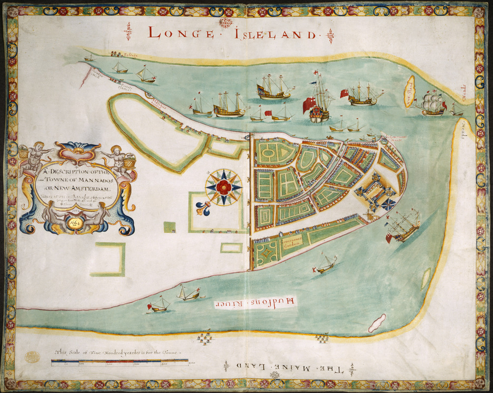
A DESCRIPTION OF THE TOWNE OF MANNADOS OR NEW AMSTERDAM as it was in September 1661 lying in Latitude 40 de: and 40,: Anno Domini 1664
Item Information
- Title:
- A DESCRIPTION OF THE TOWNE OF MANNADOS OR NEW AMSTERDAM as it was in September 1661 lying in Latitude 40 de: and 40,: Anno Domini 1664
- Former owner:
- George, III, King of Great Britain, 1738-1820
- Donor:
- George, IV, King of Great Britain, 1762-1830
- Contributor:
- James, II, King of England, 1633-1701
- Date:
-
1664
- Format:
-
Maps/Atlases
Manuscripts
- Location:
- British Library
- Collection (local):
-
British Library Collection
- Subjects:
-
Manhattan (New York, N.Y.)--Maps, Manuscript--Early works to 1800
New York (N.Y.)--Maps, Manuscript--Early works to 1800
- Places:
-
New York
- Extent:
- 1 map : manuscript watercolour on vellum with gold highlighting ; 52 x 66 cm
- Terms of Use:
-
No known copyright restrictions.
This work is licensed for use under a Creative Commons Attribution Non-Commercial Share Alike License (CC BY-NC-SA).

- Scale:
-
Scale approximately 1:2,400
- Language:
-
English
- Catalog Record:
-
http://explore.bl.uk/BLVU1:LSCOP-ALL:BLL01004987659
- Notes:
-
The so-called "Duke's Plan" of New York - named for James, Duke of York. Named the "Duke's Plan" by George H. Moore, librarian at the New York Historical Society, who re-discovered the map in the collections of the British Museum in 1858.
Likely copied from a 1661 survey by Jacques Cortelyou - Cohen and Augustyn.
Produced by an anonymous artist of the Thames School of mapmakers - Cohen and Augustyn.
"This Scale of Five Hondread yeardes is for the Towne" appears at lower left.
Shows a decorative compass rose orienting north to the left of the map.
Shows the city wall and battery - giving present-day names to Wall Street and Battery Park.
Shows warships with the English ensigns.
Names "Hudsons River".
Shows settlements in Brooklyn and on Long Island.
Names the "Governours House".
Titled "A drawn Plan of the Town of Mannados or New Amsterdam, (New York,) as it was in September, 1661. Fol." in the Catalogue of Maps, Prints, Drawings, etc., forming the geographical and topographical collection attached to the Library of his late Majesty King George the third, etc., London, 1829.
Titled "A description of the towne of Mannados or New Amsterdam, as it was in September, 1661," being a colored plan of New York (known as the 'Duke's Map' or 'Duke's Plan'); drawn in 1664 [by William Hack?], after its capture, by Sir Robert Holmes, from the Dutch: on vellum, on a scale of 65 yards to an inch: 2 f. 2 in. x 1 f. 10 in. in the Catalogue of the manuscript maps, charts, and plans, and of the topographical drawings in the British Museum.
Copy at Maps K.Top.121.35. Exhibited: John Bull & Uncle Sam : four centuries of British-American relations : a joint exhibition of the Library of Congress and the British Library. (Washington : Library of Congress, 1999). Uk


![[New York Island and the Narrows. 1781]](https://bpldcassets.blob.core.windows.net/derivatives/images/commonwealth:hx11z295d/image_thumbnail_300.jpg)
