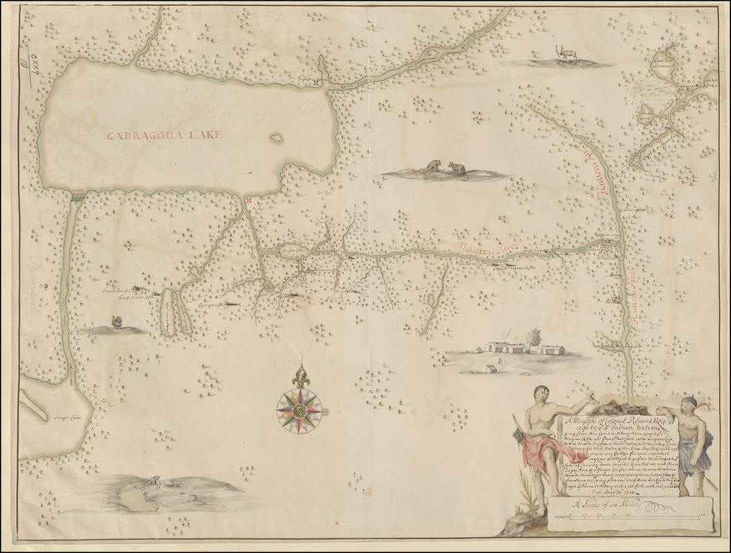
A Mappe of Colonel Römers Voyage to ye: 5 Indian nations going from New Yorck to Albany thence west to ye 3 Macquas Castle and from ye: last Castle called Daganhoge W:S:W towards Onyades a Second nation, and thence to ye Onondages the third nation, & there I was Stoped & could not proced any forther for some important reassons & obliged to go from Onondages to ye Lake of Cananda down Cananda River till we met Onnondages River & Osweges Riv: from whence we were to returne towards Onnondages having no provision & thence to Ononyedes & from thence to ye carring place wood kill & Bever kill & so to Oneyades agin & thence to Albany as it is set forth with read pricked lines
Item Information
- Title:
- A Mappe of Colonel Römers Voyage to ye: 5 Indian nations going from New Yorck to Albany thence west to ye 3 Macquas Castle and from ye: last Castle called Daganhoge W:S:W towards Onyades a Second nation, and thence to ye Onondages the third nation, & there I was Stoped & could not proced any forther for some important reassons & obliged to go from Onondages to ye Lake of Cananda down Cananda River till we met Onnondages River & Osweges Riv: from whence we were to returne towards Onnondages having no provision & thence to Ononyedes & from thence to ye carring place wood kill & Bever kill & so to Oneyades agin & thence to Albany as it is set forth with read pricked lines
- Cartographer:
- Romer, Wolfgang William, 1640-1713
- Former owner:
- George, III, King of Great Britain, 1738-1820
- Donor:
- George, IV, King of Great Britain, 1762-1830
- Name on Item:
-
Anno Do: 1700.
- Date:
-
1700
- Format:
-
Maps/Atlases
Manuscripts
- Location:
- British Library
- Collection (local):
-
British Library Collection
- Subjects:
-
Five Nations--Maps, Manuscript--Early works to 1800
New York (State)--Maps, Manuscript--Early works to 1800
Ontario, Lake (N.Y. and Ont.)--Maps, Manuscript--Early works to 1800
- Places:
-
New York
Ontario, Lake
- Extent:
- 1 map : manuscript pen and ink with watercolour ; 44 x 58 cm
- Terms of Use:
-
No known copyright restrictions.
This work is licensed for use under a Creative Commons Attribution Non-Commercial Share Alike License (CC BY-NC-SA).

- Scale:
-
Scale approximately 1:1,370,000
- Language:
-
English
- Catalog Record:
-
http://explore.bl.uk/BLVU1:LSCOP-ALL:BLL01004987682
- Notes:
-
With "A Scale of 100 Miles" at lower right measuring 4 5/8 inches.
The title appears in an illustrated cartouche at lower right flanked by Native Americans in traditional dress.
Illustrated with indigenous animals, including a turkey, a beaver and bears, and with an illustration of a traditional village.
Lake Erie is named "CADRAGQUA LAKE" and is a dominant feature on the map.
The National Archives hold a very similar (the wording of the title varies slightly and is illustrated differently) copy of the map (CO 700/New York13A) which is also referenced and illustrated in Cumming, William P. British maps of colonial America, pages 22 to 24.
Titled "A drawn Map of Colonel Romer's journey amongst the five Nations confederated with Her Majesty on the Continent of America, 1700" in the Catalogue of Maps, Prints, Drawings, etc., forming the geographical and topographical collection attached to the Library of his late Majesty King George the third, etc., London, 1829.
Titled 'A colored "mappe of Colonel Römer's voyage to the 5 Indian nations, going from New Yorck to Albany, thence west to the 3 Maquas castle, and from the last castle called Daganahoga, W.S.W. towards Onaydes, a second nation, and thence to the Onnondages, the third nation, and ther I was stoped and could not proceed any further for some important reassons, and obliged to go from Onnondages to the lake of Cananda, down Cananda river, till we met Onnondages river and the Ossweges river, from whence we we re to returne towards Onnondages, having no provision, and thence to Onongedes, and from thence to the carring place Wood Kill and Bever Kill, and so to Oneyades agin, and thence to Albany, as it is set forth with read prickled lines: anno Do. 1700;" drawn on a scale of 21 1/2 miles to an inch: 1 f. 11 in. x 1 f. 7 in.' in the Catalogue of the manuscript maps, charts, and plans, and of the topographical drawings in the British Museum.
The map extends from the north shore of Lake Ontario southwards to the eastern end of Lake Erie. The map extends eastward to include part of the River St Lawrence and the Hudson River.
Copy at Maps K.Top.121.10. Exhibited: "The European Vision of America", National Gallery of Art, Washington D.C., 7 December 1975 to 16 February 1976. Uk


![[Lake Ontario]](https://bpldcassets.blob.core.windows.net/derivatives/images/commonwealth:hx11xz576/image_thumbnail_300.jpg)
