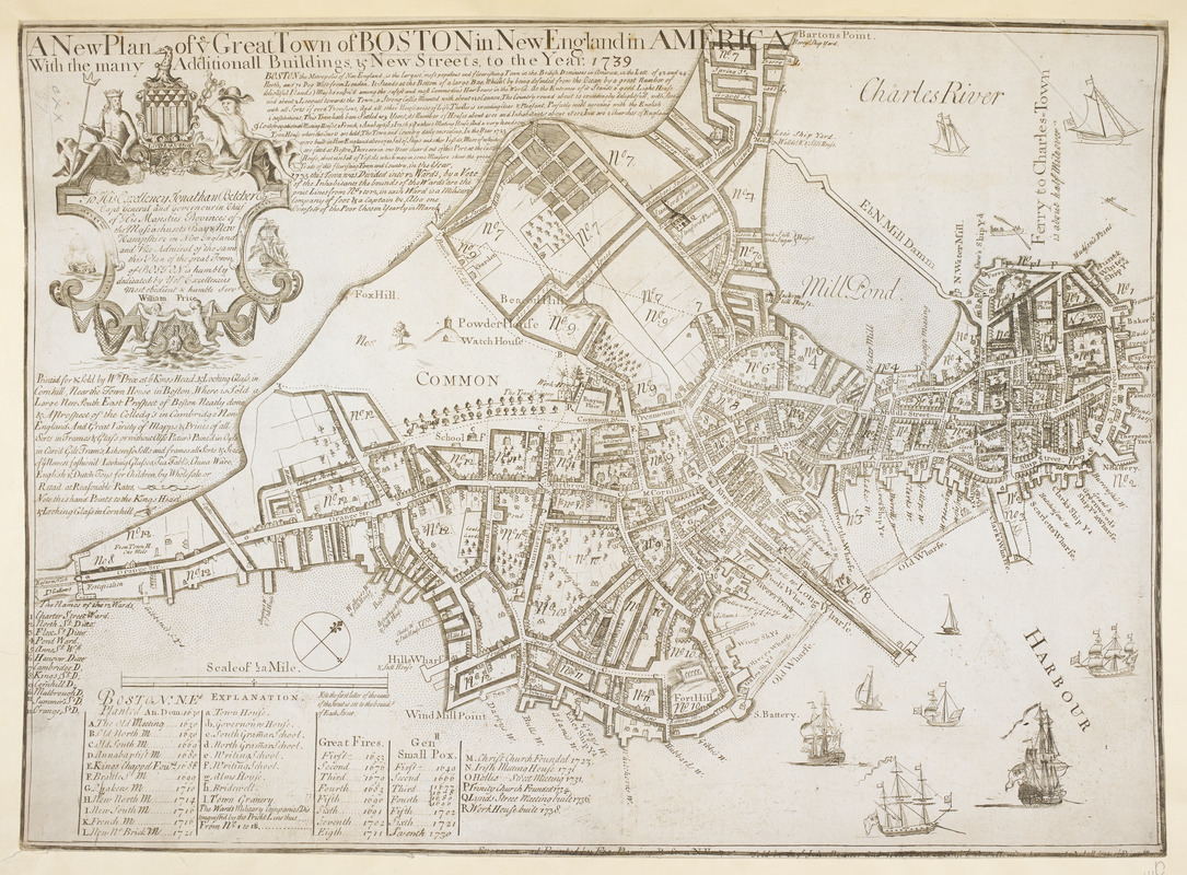
A New Plan of ye Great Town of BOSTON in New England in AMERICA with the many Additionall Buildings & New Streets to the Year, 1739
Item Information
- Title:
- A New Plan of ye Great Town of BOSTON in New England in AMERICA with the many Additionall Buildings & New Streets to the Year, 1739
- Printmaker:
- Price, William, active 1725-1769
- Former owner:
- George, III, King of Great Britain, 1738-1820
- Donor:
- George, IV, King of Great Britain, 1762-1830
- Cartographer:
- Bonner, John, approximately 1643-1726
- Dedicatee:
- Belcher, Jonathan, 1682-1757
- Contributor:
- Dewing, Francis, active 1716-1722
- Name on Item:
-
William Price.
- Date:
-
1739
- Format:
-
Maps/Atlases
- Location:
- British Library
- Collection (local):
-
British Library Collection
- Subjects:
-
Boston (Mass.)--Maps--Early works to 1800
- Places:
-
Suffolk (county)Boston
- Extent:
- 1 map : copperplate engraving with a manuscript addition in ink ; 43 x 60 cm
- Terms of Use:
-
No known copyright restrictions.
This work is licensed for use under a Creative Commons Attribution Non-Commercial Share Alike License (CC BY-NC-SA).

- Publisher:
-
[Boston] :
Printed for & Sold by Wm. Price at ye Kings Head & Looking Glass
- Scale:
-
Scale approximately 1:5,700
- Language:
-
English
- Catalog Record:
-
http://explore.bl.uk/BLVU1:LSCOP-ALL:BLL01004807150
- Notes:
-
The last two digits of the map's date (1739) are added in manuscript ink.
The sixth state (of nine) of the map and the only known example in this state - Wheat and Brun.
The first state of the map by John Bonner was engraved and published in 1722 by Francis Dewing in Boston and was the earliest engraved plan of Boston - Wheat and Brun.
Separately published.
Shows a dedication to Jonathan Belcher in a decorative surround at upper left. "To His Excellency Jonathan Belcher Esq. Capt General and Governour in Chief of His Majesties Province of the Massachusetts Bay & New Hampshire in New Hampshire in New England and Vice Admiral of the same this Plan of the great Town of BOSTON is humbly dedicated by Yor Excellencies most obedient & humble Servt. William Price".
Shows a printed text advertisement for William Price's shop beneath the dedication.
Includes a passage of descriptive text beneath the title including the town's division into wards in 1735.
Shows a lettered key at lower left.
Illustrated with numerous sailing vessels.
Many buildings shown pictorially.
Imprint detail in the lower margin is just visible, although now crossed through with a printed border; "Engraven and Printed by Fra. Dewing. Boston N.E. 1722. Sold by Capt John Bonner and Willm. Price against ye Town House where may be had all sorts of Prints, Mapps, &c.".
Titled "A Plan of the Town of Boston with the new Buildings and Streets to the year 1739, by Wm. Price" in the Catalogue of Maps, Prints, Drawings, etc., forming the geographical and topographical collection attached to the Library of his late Majesty King George the third, etc., London, 1829.


