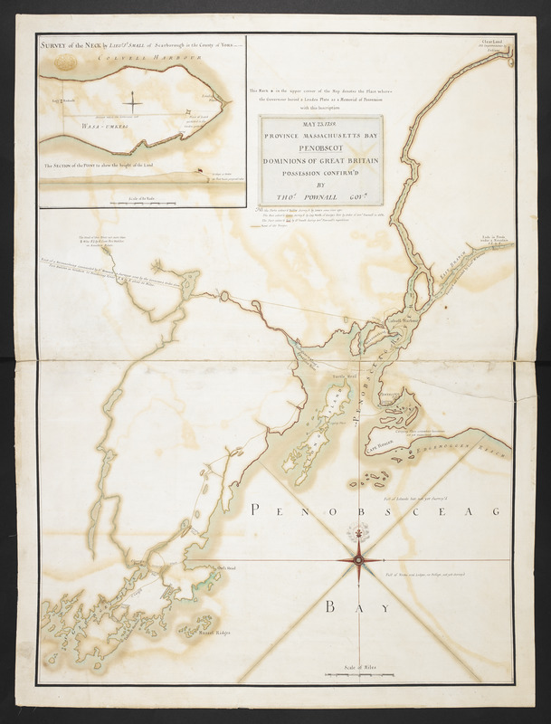
MAY 23. 1759. PROVINCE MASSACHUSETTS BAY PENOBSCOT DOMINIONS OF GREAT BRITAIN POSSESSION CONFIRM'D BY THOS. POWNALL GOVR
This map is also available in American Revolutionary Geographies Online (ARGO), a collections portal especially built for material relating to the American Revolutionary War Era. Visit ARGO to learn more about this item and explore the historical geography of North America in the late eighteenth century.
Item Information
- Title:
- MAY 23. 1759. PROVINCE MASSACHUSETTS BAY PENOBSCOT DOMINIONS OF GREAT BRITAIN POSSESSION CONFIRM'D BY THOS. POWNALL GOVR
- Former owner:
- George, III, King of Great Britain, 1738-1820
- Donor:
- George, IV, King of Great Britain, 1762-1830
- Contributor:
- Pownall, Thomas, 1722-1805
- Surveyor:
- Small, John, -1804
- Surveyor:
- North, John, 1698-1763
- Surveyor:
- Jones, Ephraim, (Surveyor)
- Date:
-
1759
- Format:
-
Maps/Atlases
Manuscripts
- Location:
- British Library
- Collection (local):
-
British Library Collection
- Subjects:
-
United States--History--French and Indian War, 1754-1763--Maps, manuscript--Early works to 1800
- Places:
-
- Extent:
- 1 map : manuscript pen and ink with watercolour ; 65 x 48 cm
- Terms of Use:
-
No known copyright restrictions.
This work is licensed for use under a Creative Commons Attribution Non-Commercial Share Alike License (CC BY-NC-SA).

- Scale:
-
Scale approximately 1:138,125
- Language:
-
English
- Catalog Record:
-
http://explore.bl.uk/BLVU1:LSCOP-ALL:BLL01004987821
- Notes:
-
Previous British Library cataloguing has dated the map 1758, although 1759 is shown on the map.
Sounding depths are given in the River Penobscot.
Shows an inset at upper left "SURVEY of the NECK by LIEUT: JO: SMALL of Scarborough in the County of York" with "The SECTION of the POINT to shew the height of the Land" at a scale of 30 rods to one inch (1:5940). Shows "Logg Redout".
A short key is given on the map "NB. The Parts colour'd Yellow Survey'd by Jones some time ago. The Part colour'd Green Survey'd by Cap. North of George's Fort by Orders of Govr. Pownall in 1758. The Part colour'd Red by Lt. Small during Govr. Pownall's expedition."
The map's titile is taken from the inscription: "This Mark * in the upper corner of the Map denotes the Place where the Governour buried a Leaden Plate as a Memorial of Possession" with this Inscription".
Shows the "Rout of a Reconnoitring commanded by Lt. Howard a Surveyor sent by the Governor's Order from Fort Halifax on Kenebeck to Penobsceag River E. & by S. about 30 Miles".
Shows "St George's Fort".
Shows a decorative compass rose orienting north to the top of the map.
No interior cartographic detail is given.
The scale at the bottom of the page is five as a "Scale of Miles".
Shows a very small "D/P" within the neatline at upper left.
Titled "A drawn Plan of the Bay and part of the River Penobscot, surveyed by order of Governor Pownall, by Jones, North, and Small, 1759" in the Catalogue of Maps, Prints, Drawings, etc., forming the geographical and topographical collection attached to the Library of his late Majesty King George the third, etc., London, 1829.
Titled "A plan of the bay and part of the river Penobscot, or Penobsceag; surveyed by order of Governor Pownall, by --- Jones, Capt. North, of George's fort, in 1758, and Lieut. Jo. Small, of Scarborough; drawn on a scale of 2 1/4 miles to an inch; with a survey and section of the neck in Wasaumskeag, in Colvell harbour, by Lieut. Small, on a scale of 31 rods to an inch: 2 f. 2 in. x 1 f. 7 in." in the Catalogue of the manuscript maps, charts, and plans, and of the topographical drawings in the British Museum.


