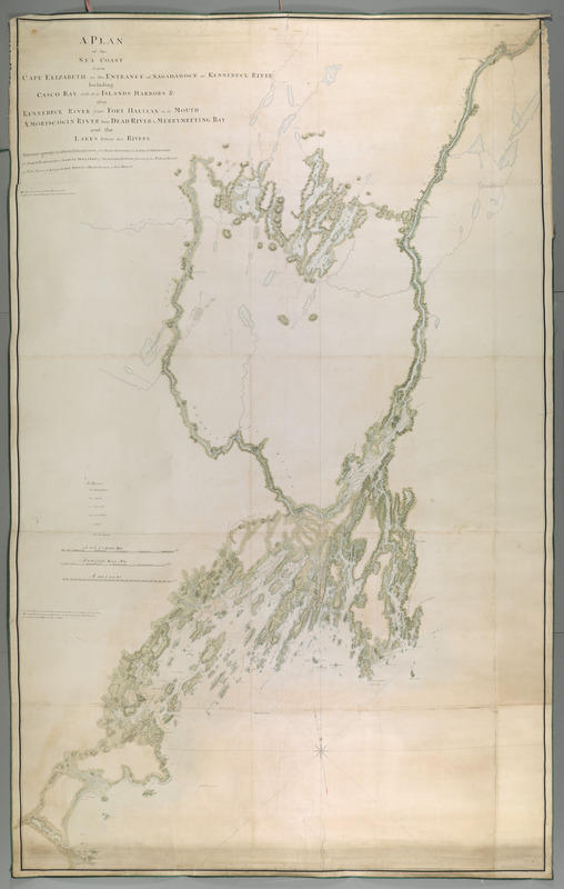
A PLAN of the SEA COAST from CAPE ELIZABETH to the ENTRANCE of SAGADAHOCK or KENNEBECK RIVER Including Casco Bay with all it's ISLANDS HARBORS, &c. also KENNEBECK RIVER from FORT HALIFAX to its MOUTH AMORISCOGIN RIVER from DEAD RIVER to MERRYMEETING BAY and the LAKES between these RIVERS
This map is also available in American Revolutionary Geographies Online (ARGO), a collections portal especially built for material relating to the American Revolutionary War Era. Visit ARGO to learn more about this item and explore the historical geography of North America in the late eighteenth century.
Item Information
- Title:
- A PLAN of the SEA COAST from CAPE ELIZABETH to the ENTRANCE of SAGADAHOCK or KENNEBECK RIVER Including Casco Bay with all it's ISLANDS HARBORS, &c. also KENNEBECK RIVER from FORT HALIFAX to its MOUTH AMORISCOGIN RIVER from DEAD RIVER to MERRYMEETING BAY and the LAKES between these RIVERS
- Creator:
- Holland, Samuel, 1728-1801
- Former owner:
- George, III, King of Great Britain, 1738-1820
- Donor:
- George, IV, King of Great Britain, 1762-1830
- Cartographer:
- Sproule, Geo. F. (George F.), 1741-1817
- Name on Item:
-
SURVEYED agreeably to the ORDERS & INSTRUCTIONS of the RIGHT HONOURABLE the LORDS COMMISSIONERS for TRADE & PLANTATIONS, to SAMUEL HOLLAND ESQR: SURVEYOR GENERAL of Lands for the Northern District of North America: by Ensign GEORGE SPROULE, a Deputy Surveyor of Said District.
- Date:
-
1772
- Format:
-
Maps/Atlases
Manuscripts
- Location:
- British Library
- Collection (local):
-
British Library Collection
- Subjects:
-
Coasts--Maine--Maps, Manuscript--Early works to 1800
Maine--Maps, Manuscript--Early works to 1800
- Places:
-
Maine
- Extent:
- 1 map on 15 sheets : joined and laid on linen, manuscript pen and ink with watercolour ; 256 x 167 cm
- Terms of Use:
-
No known copyright restrictions.
This work is licensed for use under a Creative Commons Attribution Non-Commercial Share Alike License (CC BY-NC-SA).

- Scale:
-
Scale approximately 1:48,000
- Language:
-
English
- Catalog Record:
-
http://explore.bl.uk/BLVU1:LSCOP-ALL:BLL01004987818
- Notes:
-
Relief is shown by shading.
Sounding depths are given.
The scale is given as "A Scale of Six Statute Miles" and "A Scale of 30,000 Feet" where 4000 feet is equal to one inch.
A note at lower right reads "Drawn by Ensign George Sproule".
A note beneath the title at upper left reads "NB. The Lakes Pinds and Rivers Drawn in red are taken from sketches & Draughts made by the Country Surveyors".
A short key at lower left identifies meeting houses, churches, saw mills, grist mills, roads and garrison houses.
Other parts of the survey are located at Maps K.Top.120.18., Maps K.Top.120.20. and Maps K.Top.120.21.
Titled "A drawn plan of the Sea Coast from Cape Elizabeth to the Entrance of Sagadahock or Kennebeck River, including Casco Bay, with all its Islands and Harbours: also Kennebeck River from Fort Halifax to its Mouth; Amoriscogen River from dead River to Merry-meeting Bay, and the Lakes between these rivers; surveyed agreeably to the orders of the Lords Commissioners for Trade and Plantations to Saml. Holland, Esq. by Ensign George Sproule. Ten sheets" in the Catalogue of Maps, Prints, Drawings, etc., forming the geographical and topographical collection attached to the Library of his late Majesty King George the third, etc., London, 1829.
Titled 'A colored "plan of the sea coast from Cape Elizabeth, to the entrance of Sagadahock, or Kennebeck River, including Casco Bay with all its islands, harbors, &c.; also Kennebeck River from Fort Halifax to its mouth, Amoriscogin River from Dead River to Merrymeeting Bay, and the Lakes between these Rivers; surveyed agreeably to the orders and instructions of the Lords Commissioners for Trade and Plantations to Samuel Holland, Esq., surveyor-general of lands for the northern district of North America, by Ensign George Sproule, a deputy-surveyor of said district;" drawn on a scale of 3/4 mile to an inch: 8 f. x 5 f. 3 in.' in the Catalogue of the manuscript maps, charts, and plans, and of the topographical drawings in the British Museum.

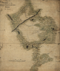
![[A map of part of New York, comprehending the country between New York and Quebec, the river Connecticut, &c., to shew "the way from Albany to Canada ..... part by land and part by water;" drawn about 1720, on a scale of 31 miles to an inch]](https://bpldcassets.blob.core.windows.net/derivatives/images/commonwealth:6108vw070/image_thumbnail_300.jpg)
![[A map of part of New York, comprehending the country between New York and Quebec, the river Connecticut, &c., to shew "the way from Albany to Canada ..... part by land and part by water;" drawn about 1720, on a scale of 31 miles to an inch]](https://bpldcassets.blob.core.windows.net/derivatives/images/commonwealth:6108vw09j/image_thumbnail_300.jpg)