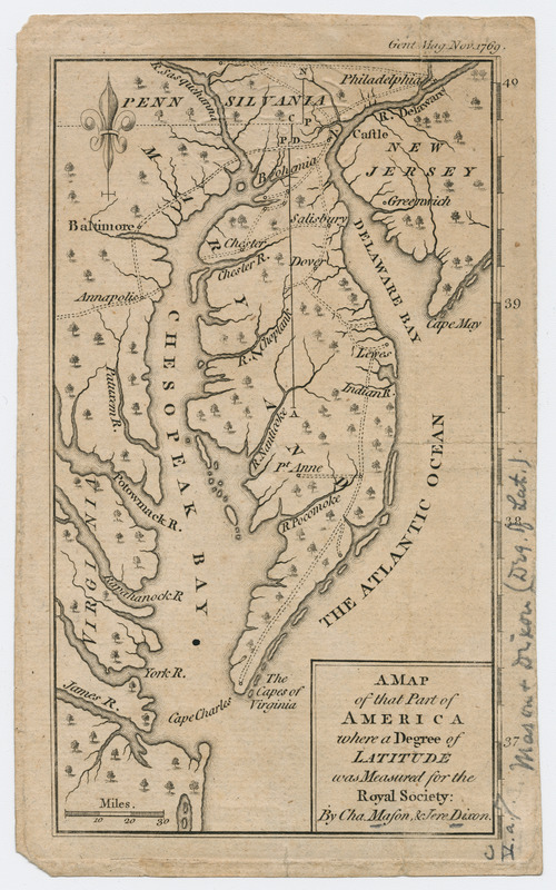
A map of that part of America where a degree of latitude was measured for the Royal Society
This map is also available in American Revolutionary Geographies Online (ARGO), a collections portal especially built for material relating to the American Revolutionary War Era. Visit ARGO to learn more about this item and explore the historical geography of North America in the late eighteenth century.
Item Information
- Title:
- A map of that part of America where a degree of latitude was measured for the Royal Society
- Title (alt.):
-
Gentleman's magazine (London, England)
- Creator:
- Mason, Charles, 1728-1786
- Contributor:
- Dixon, Jeremiah
- Name on Item:
-
by Cha. Mason & Jere. Dixon.
- Date:
-
[1769]
- Format:
-
Maps/Atlases
- Location:
- Massachusetts Historical Society
- Collection (local):
-
Massachusetts Historical Society Collection
- Subjects:
-
Middle Atlantic States--Maps--Early works to 1800
Delaware--Maps--Early works to 1800
- Places:
-
Delaware
Middle Atlantic (area)
- Extent:
- 1 map : hand col. ; 17 x 10 cm.
- Terms of Use:
-
No known copyright restrictions.
This work is licensed for use under a Creative Commons Attribution Non-Commercial Share Alike License (CC BY-NC-SA).

- Publisher:
-
London :
[s.n.]
- Scale:
-
Scale [ca. 1:2,250,000]
- Language:
-
English
- Catalog Record:
-
http://balthazaar.masshist.org/cgi-bin/Pwebrecon.cgi?DB=local&BBID=186176
- Notes:
-
Covers southern portions of Pennsylvania and New Jersey, eastern section of Maryland, Delaware, and northeastern section of Virginia.
In upper right corner: Gent. Mag. Nov. 1769.
- Notes (date):
-
This date is inferred.


![[A map of part of Pennsylvania & Maryland intended to shew, at one view, the several places proposed for opening a communication between the waters of the Delaware & Chesopeak Bays]](https://bpldcassets.blob.core.windows.net/derivatives/images/commonwealth:z603vt12v/image_thumbnail_300.jpg)


