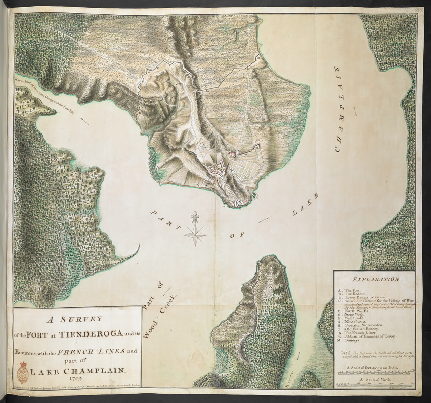
A SURVEY of the FORT at TIENDEROGA and its Environs, with the FRENCH LINES and part of LAKE CHAMPLAIN 1759
This map is also available in American Revolutionary Geographies Online (ARGO), a collections portal especially built for material relating to the American Revolutionary War Era. Visit ARGO to learn more about this item and explore the historical geography of North America in the late eighteenth century.
Item Information
- Title:
- A SURVEY of the FORT at TIENDEROGA and its Environs, with the FRENCH LINES and part of LAKE CHAMPLAIN 1759
- Description:
-
We Are One: British surveyor William Brasier prepared this plan after the British gained control of Fort Carillon and nearby Fort St. Frédéric (Crown Point) from the French in 1759. Both forts were located near the southern end of Lake Champlain. The French destroyed much of Fort Carillon when they retreated to Quebec. After repairing and renaming it Fort Ticonderoga, the British advanced to capture Quebec and Montreal. In May 1775, colonial militia seized cannons from Ticonderoga and Crown Point, which were still garrisoned by British troops. They transported the cannons to Boston and positioned them on Dorchester Heights. The move helped force the British to evacuate in March 1776.
- Cartographer:
- Brasier, William
- Surveyor:
- De Brahm, John Gerar William, 1717-approximately 1799
- Former owner:
- Amherst, Jeffery Amherst, Baron, 1717-1797
- Former owner:
- Royal United Services Institute for Defence and Security Studies
- Name on Item:
-
The Fort & Lines by Lieu.t Brheam Assistan Engin.r. the Ground Survey'd November 1759 by W: Brasier Draughtsman to the Ch: Engineer.
- Date:
-
1759
- Format:
-
Maps/Atlases
- Location:
- British Library
- Collection (local):
-
British Library Collection
- Subjects:
-
Fortification--New York (State)--Fort Ticonderoga--Maps, Manuscript--Early works to 1800
Military art and science--New York (State)--Fort Ticonderoga--Maps, Manuscript--Early works to 1800
Fort Ticonderoga (N.Y.)--Maps, Manuscript--Early works to 1800
- Places:
-
Essex (county)Fort Ticonderoga (transport point)
- Extent:
- 1 map on 2 sheets : joined, manuscript pen and ink with watercolour ; 65 x 71 cm
- Terms of Use:
-
No known copyright restrictions.
This work is licensed for use under a Creative Commons Attribution Non-Commercial Share Alike License (CC BY-NC-SA).

- Publisher:
-
[Lake George?] :
The Fort & Lines by Lieu.t Brheam Assistan Engin.r. the Ground Survey'd November 1759 by W: Brasier Draughtsman to the Ch: Engineer,
- Scale:
-
Scale approximately 1:4,800
- Language:
-
English
- Catalog Record:
-
http://searcharchives.bl.uk/IAMS_VU2:IAMS040-001999744
- Notes:
-
Relief shown by shading and by hachuring.
Shows title and statement of responsibility in a simple surround at lower left.
Shows lettered key (A-M) in a simple surround at lower right incorporating scale bars, "A Scale of feet 400 to an Inch" and "A Scale of Yards".
Compare "PLAN of the FORT at TIENDEROGA and Environs, at the head of LAKE CHAMPLAIN November 1759 The Fort & Lines Survey'd by Lieu.t Brheam Assist. Engin.r, the Ground by W.m Brasier. W.m Brasier Del.t" (see Maps K.Top.121.106.).
Copy at Add Ms 57,712.10. Bound in R.U.S.I. Vol LXXVII. Shows manuscript addition of "10" in pencil at upper right. Laid on archival tissue. Green circular label to verso shows "48", with "49" added in pencil adjacent. White label to verso shows "DRAWER 30 SECTION 3". Blue label to verso shows "A 30/74", repeated in pencil. Pencil annotation shows "C 42" and "No 84". Large pencil annotation shows "Add 57712 f.10 AWI 84". Paper watermark shows "J VILLDARY"
Exhibited: The American War of Independence 1775-83. A commemorative exhibition organized by the Map Library and the Department of Manscuscripts of the British Library Reference Division 4 July to 11 November 1975
This map can be viewed as a georeferenced overlay in an interactive application made especially for We Are One: Mapping America's Road from Revolution to Independence http://d2o8owo4k087al.cloudfront.net/index.html?mapId=49.
- Notes (exhibitions):
-
Exhibited: "We Are One: Mapping America's Road from Revolution to Independence" organized by the Norman B. Leventhal Map Center at the Boston Public Library, 2015.

![[Map of Fort Carillon]](https://bpldcassets.blob.core.windows.net/derivatives/images/commonwealth:hx11z179t/image_thumbnail_300.jpg)
![[PLAN de Carillon]](https://bpldcassets.blob.core.windows.net/derivatives/images/commonwealth:hx11z1778/image_thumbnail_300.jpg)