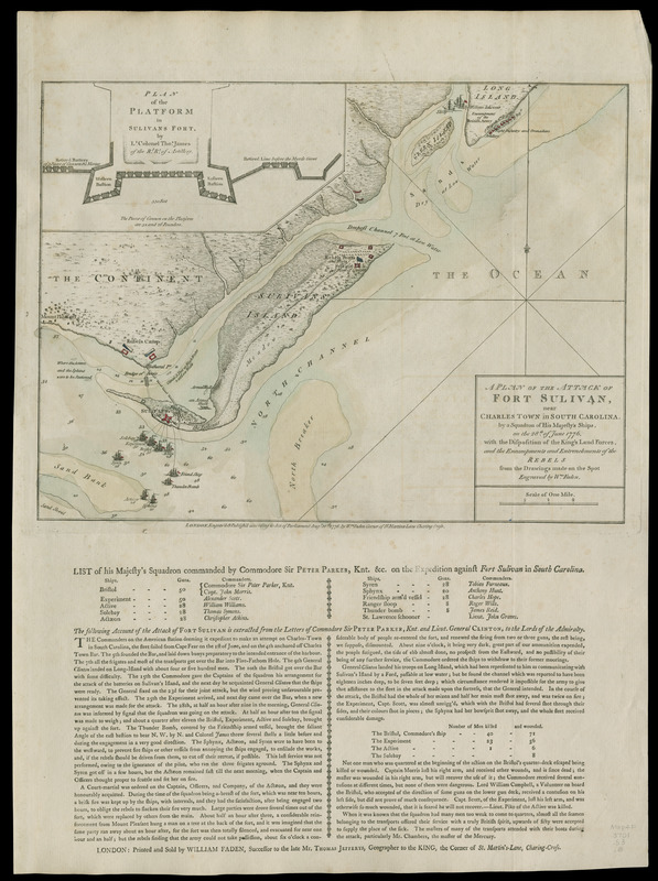
A plan of the attack of Fort Sulivan, near Charles Town in South Carolina : by a squadron of His Majesty's ships, on the 28th. of June 1776 : with the disposition of the King's land forces, and the encampments and entrenchments of the rebels
This map is also available in American Revolutionary Geographies Online (ARGO), a collections portal especially built for material relating to the American Revolutionary War Era. Visit ARGO to learn more about this item and explore the historical geography of North America in the late eighteenth century.
Item Information
- Title:
- A plan of the attack of Fort Sulivan, near Charles Town in South Carolina : by a squadron of His Majesty's ships, on the 28th. of June 1776 : with the disposition of the King's land forces, and the encampments and entrenchments of the rebels
- Creator:
- Faden, William, 1749-1836
- Name on Item:
-
from the drawings made on the spot ; engraved by Wm. Faden
- Date:
-
1776
- Format:
-
Maps/Atlases
Manuscripts
- Location:
- Newberry Library
- Collection (local):
-
Edward E. Ayer Collection
- Subjects:
-
Sullivans Island (S.C.)--Maps
United States--History--Revolution, 1775-1783--Maps
- Places:
-
South CarolinaCharleston (county)Sullivan's Island (island)Sullivans Island
- Extent:
- 1 map : hand col. ; 28 x 38 cm. on sheet 55 x 41 cm.
- Terms of Use:
-
No known copyright restrictions.
Contact host institution for more information.
- Publisher:
-
London :
William Faden
- Scale:
-
Scale [ca. 1:26,200]
- Catalog Record:
-
https://i-share-nby.primo.exlibrisgroup.com/permalink/01CARLI_NBY/i5mcb2/alma998999408805867
- Notes:
-
Soundings shown in feet.
Inset: Plan of the platform in Sulivans Fort, by Lt. Colonel Thos. James.
A 'List of His Majesty's squadron' and an 'Account of the attack of Fort Sullivan' are printed in letterpress below the map.
Detached from: Faden, William, [Atlas of battle plans, ca. 1783], no. 8.
The atlas was previously owned by British general Sir Henry Clinton.
- Call #:
-
Map4F 3701.S3.8 (PrCt)