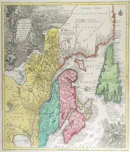
Carte de la rivire du Cannada, la Terre Nevf, Cape Britton et la cotte de Lacadie

This map is also available in American Revolutionary Geographies Online (ARGO), a collections portal especially built for material relating to the American Revolutionary War Era. Visit ARGO to learn more about this item and explore the historical geography of North America in the late eighteenth century.
Item Information
- Title:
- Carte de la rivire du Cannada, la Terre Nevf, Cape Britton et la cotte de Lacadie
- Title (alt.):
-
Carte de la riviere du Canada, la Terre Neuf, Cape Breton et la côte de l'Acadie
Carte du golfe et fleuve St. Laurens
- Description:
-
Nautical chart detailing the coasts, rivers, and towns of the Canadian region bounded by Newfoundland, Nova Scotia, the Saint Lawrence River valley to the city of Québec, and the Atlantic coast south to Cape Cod.
- Creator:
- Olivier, Abel, 1683?-1768
- Name on Item:
-
fait par votre tres humble obéissant serviteur Ábél, Squire [?], anno 1747.
- Date:
-
1747
- Format:
-
Maps/Atlases
Manuscripts
- Location:
- Newberry Library
- Collection (local):
-
Everett D. Graff Collection of Western Americana
- Subjects:
-
Nautical charts--Canada--Early works to 1800
Nautical charts--New France--Early works to 1800
Coasts--Canada--Maps--Early works to 1800
Coasts--New France--Maps--Early works to 1800
Manuscript maps--Early works to 1800
Canada--Maps--Early works to 1800
New France--Maps--Early works to 1800
St. John's (N.L.)--Maps--Early works to 1800
- Places:
-
CanadaNewfoundland and Labrador (province)Saint John's
- Extent:
- 1 ms. map : hand col. ; on sheet 511 x 885 mm.
- Terms of Use:
-
No known copyright restrictions.
Contact host institution for more information.
- Scale:
-
Scale [ca. 1:2,050,000]
- Language:
-
French
- Catalog Record:
-
https://i-share-nby.primo.exlibrisgroup.com/permalink/01CARLI_NBY/i5mcb2/alma991482548805867
- Notes:
-
Probably compiled by Abel Olivier, an English ship captain active in French colonial shipping; cf Dict. of Canadian Biog., v. 2.
Title on verso: Carte du Golfe et Fleuve St. Laurens / M. Abel.
Inset in oval border 195 x 210 mm.: Havre St. Jean. Identifies several landowners.
Pen-and-ink and watercolor (green, red, yellow); sectioned and mounted on cloth.
- Call #:
-
Ayer MS map 209