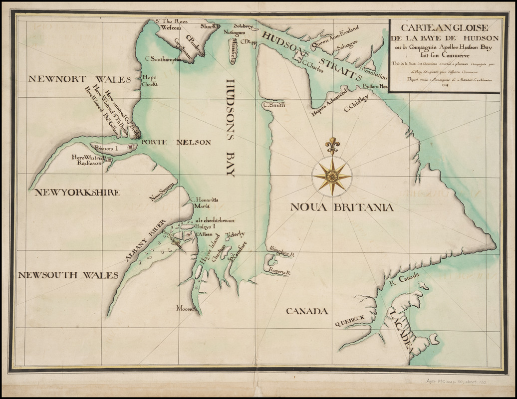
Carte angloise de la Baye de Hudson ou la compagnie apellee Hudson Bay fait son commerce : tirée de la liasse des concecions accordée a plusiers compagnis par le Roy l'Angleterre pour differens commerces ; depost remise a Monseigneur le Marechal le 8 Novembre, 1719
Item Information
- Title:
- Carte angloise de la Baye de Hudson ou la compagnie apellee Hudson Bay fait son commerce : tirée de la liasse des concecions accordée a plusiers compagnis par le Roy l'Angleterre pour differens commerces ; depost remise a Monseigneur le Marechal le 8 Novembre, 1719
- Description:
-
French copy of an unidentified English map probably compiled in the previous century; most place names in English. Illustrates the competing fur trade claims of Hudson's Bay Company and the Compagnie du Nord; identifies sites associated with the early European exploration of Hudson Bay, particularly the 1682-1683 expedition headed by Pierre Esprit Radisson and Médard Chouart Des Groseilliers. Prominently labels the Nelson River winter camps of Radisson, HBC governor John Bridgar, ship captain Benjamin Gillam, and Sir Thomas Button (Button's expedition wintered there in 1612).
- Contributor:
- Le Marechal, fl. 1719
- Date:
-
1719
- Format:
-
Maps/Atlases
Manuscripts
- Location:
- Newberry Library
- Collection (local):
-
Edward E. Ayer Collection
- Subjects:
-
Hudson's Bay Company--Maps--Early works to 1800
Compagnie du Nord--Maps--Early works to 1800
Fur trade--Hudson Bay--Maps--Early works to 1800
Manuscript maps--Early works to 1800
Hudson Bay--Maps--Early works to 1800
Hudson Bay--Discovery and exploration--Maps--Early works to 1800
Radisson, Pierre Esprit, ca. 1636-1710
Des Groseilliers, Médard Chouart, sieur, b. 1618
Bridgar, John, fl. 1678-1687
Gillam, Benjamin
Button, Thomas, Sir, d. 1634
- Places:
-
CanadaHudson Bay
- Extent:
- 1 ms. map : hand col. ; 493 x 685 mm., on sheet 563 x 730 mm.
- Terms of Use:
-
No known copyright restrictions.
Contact host institution for more information.
- Scale:
-
Scale not given
- Language:
-
French
English
- Catalog Record:
-
https://i-share-nby.primo.exlibrisgroup.com/permalink/01CARLI_NBY/i5mcb2/alma991815078805867
- Notes:
-
Monseigneur le Marechal not identified, but possibly a commissioner involved in North American boundary negotiations held in Paris during 1719; cf. Smith.
Sheet 110 of 115 (i.e. 117; includes sheets 71A and 106A) numbered leaves in the Cartes Marines Manuscript Map Collection, detailing French colonial interests worldwide, ca. 1640-ca. 1726.
Pen-and-ink and watercolor (green, grey, brown, yellow, red); mounted on cloth.
- Call #:
-
Ayer MS map 30 sheet 110

![Carte des découvertes qui ont été faites dans la partie occidentale du Canada sur les mémoires de Mr de la Varanderie [Vérendrye]](https://bpldcassets.blob.core.windows.net/derivatives/images/commonwealth:wp98ck41z/image_thumbnail_300.jpg)
