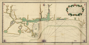
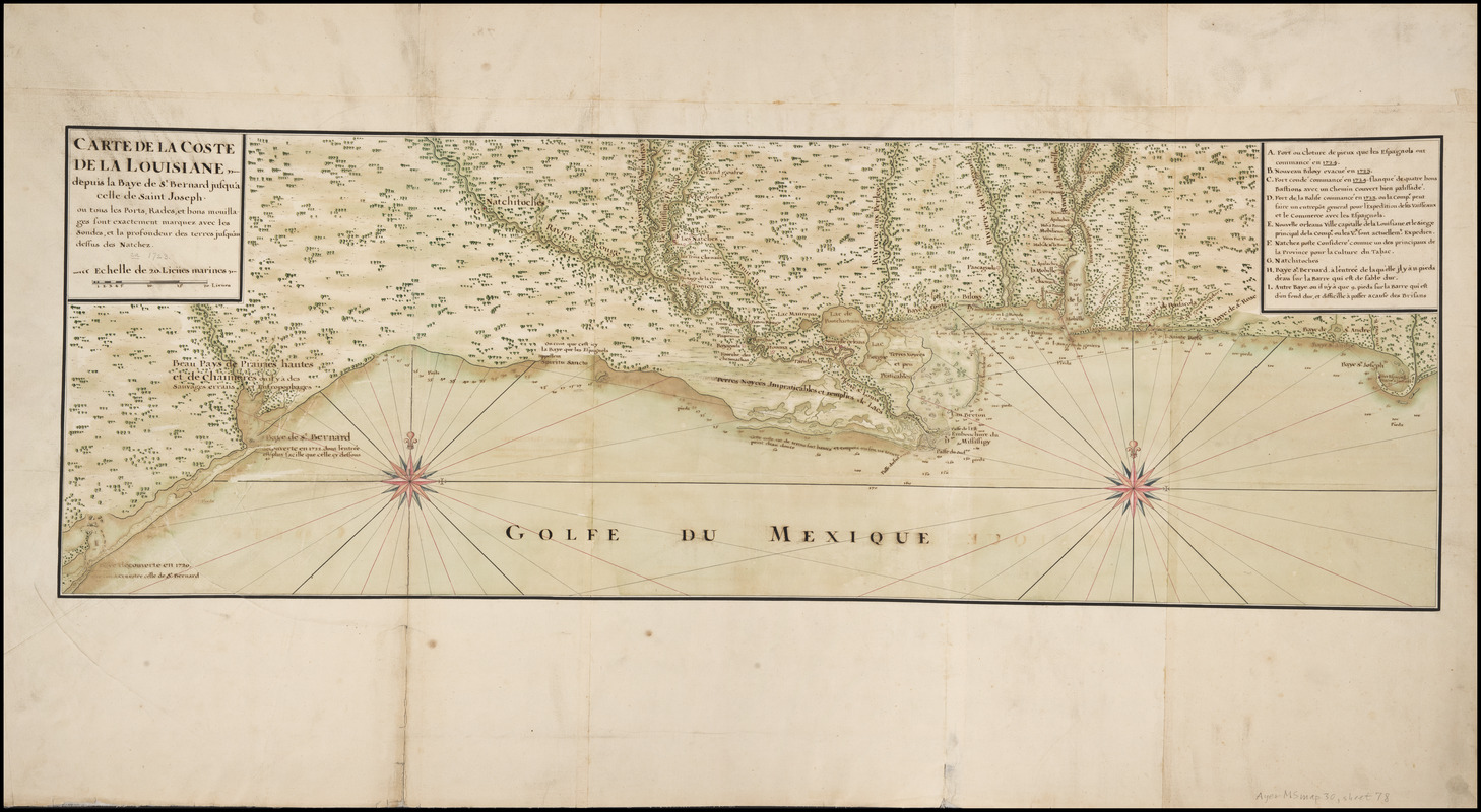
Carte de la coste de la Louisiane, depuis la Baye de St. Bernard jusqu'a celle de Saint Joseph : ou tous les ports, rades, et bons mouillages sont exactement marquez avec les sondes, et la profondeur des terres jusqu'au dessus des Natchez
Item Information
- Title:
- Carte de la coste de la Louisiane, depuis la Baye de St. Bernard jusqu'a celle de Saint Joseph : ou tous les ports, rades, et bons mouillages sont exactement marquez avec les sondes, et la profondeur des terres jusqu'au dessus des Natchez
- Description:
-
Nautical chart of the Gulf of Mexico coast from Matagorda Bay, Texas east through Louisiana, Mississippi and Alabama to Saint Joseph Bay, Florida. Compiled following the 1721 expedition undertaken by Valentin Devin, Jean Béranger, and Jean-Baptiste de La Harpe in search of Robert Cavelier de La Salle's earlier landing site at Matagorda Bay; the latter expedition landed instead at Galveston Bay. Includes references A-I.
- Creator:
- Devin, Valentin
- Contributor:
- Pauger, Adrien, fl. 1722
- Date:
-
[1726]
- Format:
-
Maps/Atlases
Manuscripts
- Location:
- Newberry Library
- Collection (local):
-
Louis C. Karpinski Map Collection
- Subjects:
-
Coasts--Gulf Coast (U.S.)--Maps--Early works to 1800
Nautical charts--Gulf Coast (U.S.)--Early works to 1800
Manuscript maps--Early works to 1800
Gulf Coast (U.S.)--Maps--Early works to 1800
Devin, Valentin
Bénard de La Harpe, Jean Baptiste, 1683-1765
Béranger, Jean
- Places:
-
Alabama
Texas
Louisiana
Mississippi
- Extent:
- 1 ms. map : hand col. ; 314 x 929 mm., on sheet 557 x 1,000 mm.
- Terms of Use:
-
No known copyright restrictions.
Contact host institution for more information.
- Scale:
-
Scale [ca. 1:1,540,000]
- Language:
-
French
- Catalog Record:
-
https://i-share-nby.primo.exlibrisgroup.com/permalink/01CARLI_NBY/i5mcb2/alma991759858805867
- Notes:
-
Sheet 78 of 115 (i.e. 117; includes sheets 71A and 106A) numbered leaves in the Cartes Marines Manuscript Map Collection, detailing French colonial interests worldwide, ca. 1640-ca. 1726.
Depths shown with soundings.
Pen-and-ink and watercolor (green, brown, red, blue); mounted on cloth.
Anonymous copy of map by Valentin Devin probably derived from earlier work by Adrien Pauger; see Jackson, J. Manuscript maps concerning the Gulf Coast (Chicago: Hermon Dunlap Smith Center for the History of Cartography, 1995) p. 36, no. 175.
A variant ms. copy is held by the Library of Congress (G3860 1732 .C Vault). Another variant (location unknown) was partially reproduced in Villiers du Terrage, Marc de. "Les indiens du Texas et les expeditions françaises de 1720 et 1721 à la Baie Saint-Bernard" in Journal de la Société des Américanistes de Paris, N.S. v. 11, no. 2 (1919), pl. 4, opposite p. 417.
- Notes (date):
-
This date is inferred.
- Call #:
-
Ayer MS map 30 sheet 78 (NLO)