A map of the British and French dominions in North America : with the roads, distances, limits, and extent of the settlements
This map is also available in American Revolutionary Geographies Online (ARGO), a collections portal especially built for material relating to the American Revolutionary War Era. Visit ARGO to learn more about this item and explore the historical geography of North America in the late eighteenth century.
Item Information
- Title:
- A map of the British and French dominions in North America : with the roads, distances, limits, and extent of the settlements
- Creator:
- Mitchell, John, 1711-1768
- Publisher:
- Cóvens et Mortier
- Name on Item:
-
by Jno. Mitchell, D.F. with improvements
- Date:
-
[1755–1761]
- Format:
-
Maps/Atlases
- Location:
- Boston Athenaeum
- Collection (local):
-
Cartographic Collection
- Subjects:
-
North America--Maps--Early works to 1800
British--America--Maps--Early works to 1800
Maps--North America--1750-1760
Maps--North America--1760-1770
- Places:
-
North America (area)
- Extent:
- 1 map : col. ; 133 x 191 cm., sheet 135 x 197 cm.
- Terms of Use:
-
Collection of the Boston Athenaeum. May not be reproduced or quoted without written permission. For more information, see http://www.bostonathenaeum.org/node/46
Contact host institution for more information.
- Publisher:
-
At Amsterdam :
Printed for I. Covens and C. Mortier
- Scale:
-
Scale ca. 1:2,000,000
- Language:
-
English
- Catalog Record:
-
http://catalog.bostonathenaeum.org/vwebv/holdingsInfo?bibId=91863
- Notes:
-
Relief shown pictorially.
Second Dutch edition.
From: Cóvens and Mortier. Atlas nouveau, contenant les parties du mond [1683-1761] v.9, no. 47-50.
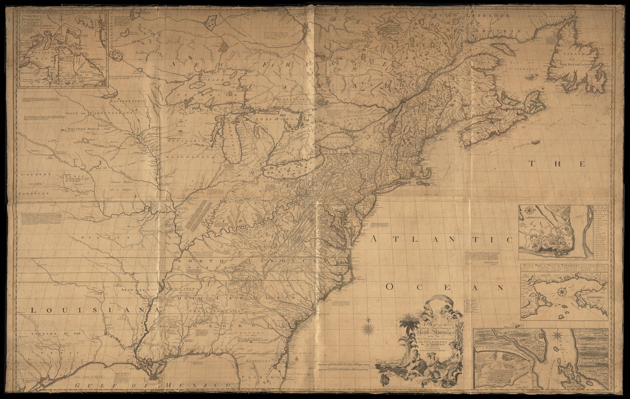
Map covers the area from James Bay to the Gulf of Mexico and from the Atlantic coast to the Great Plains. It shows provinces, some counties, numerous towns and cities, frontier settlements, forts, roads, distances between major towns, rivers and lakes, portages, waterfalls, Indian villages and tribal territory, English "Factories" among the Indians mineral deposits, early routes of exploration, a few battlegrounds, and relief. Also shown are the fishing grounds in the North Atlantic and channels in the St. Lawrence River and the Great Lakes. The map includes numerous historical and descriptive notes, references to symbols, and insets.
Insets: A new map of Hudson's Bay and Labrador from the late surveys of those coasts -- Plan de la ville de Quebec -- Plan du port et ville de Louisbourg dans l'Isle Royale -- Plan of the town of Halifax in Nova Scotia.
Includes text.
- Notes (date):
-
This date is inferred.
- Notes (citation):
-
Maps of North America, 1750-1789, 44
- Notes (object):
-
Hand colored.
- Barcode:
-
31807008489800


