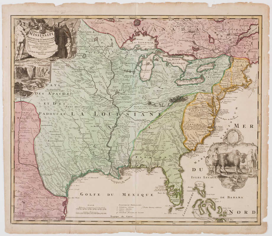
Amplissima regionis Mississipi : seu provinciae Ludoviciana à R.P. Ludovico Hennepin Francise Miss. in America Septentrionali anno 1687 detectae, nunc gallorum coloniis et actionum negotiis toto orbe celeberrimae
This map is also available in American Revolutionary Geographies Online (ARGO), a collections portal especially built for material relating to the American Revolutionary War Era. Visit ARGO to learn more about this item and explore the historical geography of North America in the late eighteenth century.
Item Information
- Title:
- Amplissima regionis Mississipi : seu provinciae Ludoviciana à R.P. Ludovico Hennepin Francise Miss. in America Septentrionali anno 1687 detectae, nunc gallorum coloniis et actionum negotiis toto orbe celeberrimae
- Title (uniform):
-
Atlas geographicus major
- Description:
-
Subject: Map of the United States showing the territory of Louisiana stretching west to New Mexico, north into Canada, and east in to New York state. Florida is shown with its territory stretching as far north as Maryland. A vignette near the Ohio River shows Native Americans hunting deer or bison with bows and arrows. Cartouche in upper left shows a priest, perhaps Hennepin, with allegorical figures, with a view of Niagara Falls and beavers below. At far right is a cartouche with a seal above it. The cartouche shows a bison, pelican and a Native American man and woman, the woman carrying an infant on her back in a cradleboard.
- Donor:
- Tinker, Edward Larocque, 1881-1968
- Publisher:
- Homann, Johann Baptist, 1663-1724
- Date:
-
[1763?]
- Format:
-
Maps/Atlases
- Location:
- American Antiquarian Society
- Collection (local):
-
American Antiquarian Society Collection
- Subjects:
-
Indians of North America--Pictorial works
American bison--Pictorial works
Niagara Falls (N.Y. and Ont.)--Pictorial works
United States--Maps
- Places:
-
Niagara Falls
- Extent:
- 1 map : engraving, hand colored ; 49 x 59 cm., on sheet 54 x 62 cm.
- Terms of Use:
-
Public Domain/No known restrictions on use. Contact host institution to download image.
Contact host institution for more information.
- Publisher:
-
[Nuremburg] :
Nova tabula edita a Io. Bapt. Homanno S.C.M. geographo, Norimbergae.
- Scale:
-
Scale [ca. 1:6,500,000]
- Language:
-
Latin
- Catalog Record:
-
http://catalog.mwa.org/vwebv/holdingsInfo?bibId=489694
- Notes:
-
Relief shown pictorially.
From Homann Erben Atlas geographicvs major, Nuremberg, ca. 1759.


