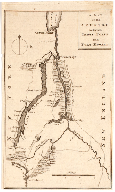
A Map of the country between Crown Point and Ford Edward
This map is also available in American Revolutionary Geographies Online (ARGO), a collections portal especially built for material relating to the American Revolutionary War Era. Visit ARGO to learn more about this item and explore the historical geography of North America in the late eighteenth century.
Item Information
- Title:
- A Map of the country between Crown Point and Ford Edward
- Title (uniform):
-
Gentleman's magazine (London, England)
- Description:
-
Subject: Map of the area from Ford Edward on the Hudson River, to Crown Point, near Lake Champlain. Fort William Henry, Lake George and the "Drown'd Islands" are seen in the land between the two forts.
- Date:
-
[1759]
- Format:
-
Maps/Atlases
- Location:
- American Antiquarian Society
- Collection (local):
-
American Antiquarian Society Collection
- Subjects:
-
New York (State)--Maps
George, Lake, Region (N.Y.)--Maps
- Places:
-
George, Lake
- Extent:
- 1 map : engraving ; 19 x 12 cm., on sheet 20 x 12 cm.
- Terms of Use:
-
Public Domain/No known restrictions on use. Contact host institution to download image.
Contact host institution for more information.
- Publisher:
-
London :
[s.n.]
- Scale:
-
Scale [ca. 1:525,000]
- Language:
-
English
- Catalog Record:
-
http://catalog.mwa.org/vwebv/holdingsInfo?bibId=488449
- Notes:
-
Relief shown pictorially.
From Gentleman's magazine, London, 1759.
- Notes (date):
-
This date is inferred.


