[Map of the towns of Western Massachusetts]
![[Map of the towns of Western Massachusetts]](https://bpldcassets.blob.core.windows.net/derivatives/images/commonwealth:6108vv02d/image_access_800.jpg)
This map is also available in American Revolutionary Geographies Online (ARGO), a collections portal especially built for material relating to the American Revolutionary War Era. Visit ARGO to learn more about this item and explore the historical geography of North America in the late eighteenth century.
Item Information
- Title:
- [Map of the towns of Western Massachusetts]
- Description:
-
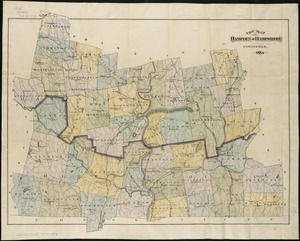
Subject: Map of Western Massachusetts, including the Berkshires and Pioneer Valley, showing land divided into named towns and numbered plots. Includes parts of Berkshire, Hampden, Hampshire and Franklin counties.
- Former owner:
- Davis, Horace, 1831-1916
- Date:
-
[1762–1783]
- Format:
-
Maps/Atlases
Manuscripts
- Location:
- American Antiquarian Society
- Collection (local):
-
American Antiquarian Society Collection
- Subjects:
-
Massachusetts--Maps
Berkshire County (Mass.)--Maps
Hampden County (Mass.)--Maps
Hampshire County (Mass.)--Maps
Franklin County (Mass.)--Maps
- Places:
-
Franklin (county)
Hampshire (county)
Hampden (county)
Berkshire (county)
- Extent:
- 1 ms. map : ink ; 71 x 63 cm.
- Terms of Use:
-
Public Domain/No known restrictions on use. Contact host institution to download image.
Contact host institution for more information.
- Scale:
-
Scale not given
- Language:
-
English
- Catalog Record:
-
http://catalog.mwa.org/vwebv/holdingsInfo?bibId=490573
- Notes:
-
Title supplied by cataloger.
The plot for the town of Murrayfield states that land was sold in June, 1762. Murrayfield, Massachusetts, became the town of Chester in 1783.
- Notes (date):
-
This date is inferred.