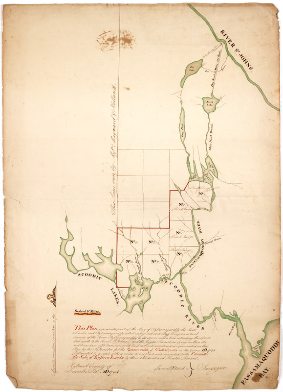
This plan represents par of the Bay of Passamoquoddy : the rivers Scoodic and Passamaquoddy which empty into said bay being an actual survey of the River Passamaquoddy to its source and a line extending there from due north to the River St. Johns--and the eight townships lying within the red lines have also been surveyed laid out and numbered as represented on this plan by the subscriber for the commonwealth of Massachusetts in the year AD 1794. Delineated by a scale of three miles to one inch and inscribed to the committee for sale of eastern lands by their obedient and humble servant
This map is also available in American Revolutionary Geographies Online (ARGO), a collections portal especially built for material relating to the American Revolutionary War Era. Visit ARGO to learn more about this item and explore the historical geography of North America in the late eighteenth century.
Item Information
- Title:
- This plan represents par of the Bay of Passamoquoddy : the rivers Scoodic and Passamaquoddy which empty into said bay being an actual survey of the River Passamaquoddy to its source and a line extending there from due north to the River St. Johns--and the eight townships lying within the red lines have also been surveyed laid out and numbered as represented on this plan by the subscriber for the commonwealth of Massachusetts in the year AD 1794. Delineated by a scale of three miles to one inch and inscribed to the committee for sale of eastern lands by their obedient and humble servant
- Description:
-
Subject: Map of the area of northern Maine showing plots of land near the Scoodic Lakes and Passamaquoddy River inland from the Passamaquoddy Bay along the present day Canadian border in Washington County, Maine.
- Creator:
- Titcomb, Samuel
- Name on Item:
-
Samuel Titcomb surveyor. Hallowell County of Lincoln Decr. AD 1794.
- Date:
-
[1794]
- Format:
-
Maps/Atlases
Manuscripts
- Location:
- American Antiquarian Society
- Collection (local):
-
American Antiquarian Society Collection
- Subjects:
-
Maine--Maps
Saint Croix River (Me. and N.B.)--Maps
- Places:
-
Maine
Saint Croix River
- Extent:
- 1 ms. map : ink and watercolor ; 76 x 54 cm.
- Terms of Use:
-
Public Domain/No known restrictions on use. Contact host institution to download image.
Contact host institution for more information.
- Scale:
-
Scale [ca. 1:190,080]
- Language:
-
English
- Catalog Record:
-
http://catalog.mwa.org/vwebv/holdingsInfo?bibId=490451
- Notes (date):
-
This date is inferred.
![[Map of the area along the Saint Croix River in Maine and New Brunswick]](https://bpldcassets.blob.core.windows.net/derivatives/images/commonwealth:6108vt00n/image_thumbnail_300.jpg)


