An accurate map, of the District of Maine : being part of the commonwealth of Massachusetts
This map is also available in American Revolutionary Geographies Online (ARGO), a collections portal especially built for material relating to the American Revolutionary War Era. Visit ARGO to learn more about this item and explore the historical geography of North America in the late eighteenth century.
Item Information
- Title:
- An accurate map, of the District of Maine : being part of the commonwealth of Massachusetts
- Description:
-
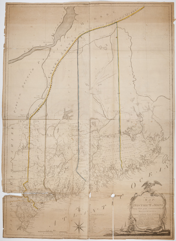
Subject: Map of the state of Maine with plots of land numbered and divided. An eagle sits atop the cartouche, and a figure is seen in a small sailboat with a lighthouse seen in the background at left.
- Creator:
- Carleton, Osgood, 1742-1816
- Publisher:
- Carleton, Osgood, 1742-1816
- Bookseller:
- Norman, John, 1748?-1817
- Bookseller:
- Norman, William, -1807
- Name on Item:
-
By Osgd. Carelton.
- Date:
-
[1795]
- Format:
-
Maps/Atlases
- Location:
- American Antiquarian Society
- Collection (local):
-
American Antiquarian Society Collection
- Subjects:
-
Maine--Maps
- Places:
-
Maine
- Extent:
- 1 map on 4 sheets ; 136 x 98 cm., 138 x 101 cm., sheets 70 x 52 cm.
- Terms of Use:
-
Public Domain/No known restrictions on use. Contact host institution to download image.
Contact host institution for more information.
- Publisher:
-
Boston :
Published and sold by O. Carleton & J. Norman sold also by Wm. Norman no. 75 Newbury Street.
- Scale:
-
Scale [ca. 1:337,920]
- Language:
-
English
- Catalog Record:
-
http://catalog.mwa.org/vwebv/holdingsInfo?bibId=462344
- Notes:
-
Prime meridian: Washington.
Relief shown pictorially.
"Explanation."
"N.B. As the surveys of some towns were not so full as others the roads & streams of those towns have been unavoidably discontinued."
Dated 1795 by Evans. Osgood Carleton was only sold maps in 1795.
- Notes (date):
-
This date is inferred.
![[Map of the area along the Saint Croix River in Maine and New Brunswick]](https://bpldcassets.blob.core.windows.net/derivatives/images/commonwealth:6108vt00n/image_thumbnail_300.jpg)


