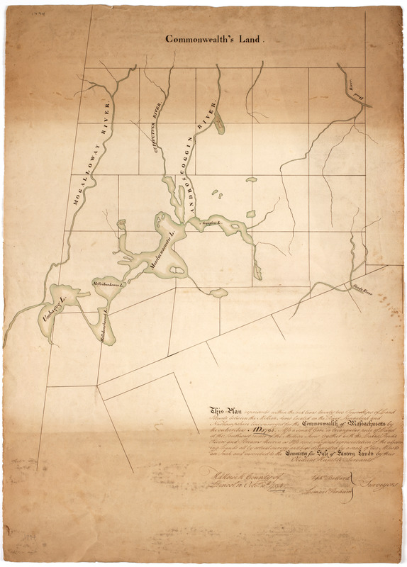
This plan represents within the red lines twenty two townships of land situate between the million acres located on the River Kennebeck and Newhampshire line : surveyed for the Commonwealth of Massachusetts by the subscribers AD 1794. Also a small gore or triangular piece of land at the southwest corner of the million acres together with the lakes, ponds, rivers and streams theirin as also some marginal representation of the adjoining lands all by actual survey and here delineated by a scale of two miles to an inch and inscribed to the committee for sale of eastern lands by their obedient humble servants
This map is also available in American Revolutionary Geographies Online (ARGO), a collections portal especially built for material relating to the American Revolutionary War Era. Visit ARGO to learn more about this item and explore the historical geography of North America in the late eighteenth century.
Item Information
- Title:
- This plan represents within the red lines twenty two townships of land situate between the million acres located on the River Kennebeck and Newhampshire line : surveyed for the Commonwealth of Massachusetts by the subscribers AD 1794. Also a small gore or triangular piece of land at the southwest corner of the million acres together with the lakes, ponds, rivers and streams theirin as also some marginal representation of the adjoining lands all by actual survey and here delineated by a scale of two miles to an inch and inscribed to the committee for sale of eastern lands by their obedient humble servants
- Description:
-
Subject: Map of the area in northwestern Maine along the New Hampshire border. Shows plots for towns near the Androscoggin River watershed.
- Creator:
- Ballard, Ephraim
- Contributor:
- Perham, Lemuel, 1764-1833
- Name on Item:
-
Ephm. Ballard, Lemuel Perham surveyors. Hallowell County of Lincoln Octor. 10th 1794.
- Date:
-
[1794]
- Format:
-
Maps/Atlases
Manuscripts
- Location:
- American Antiquarian Society
- Collection (local):
-
American Antiquarian Society Collection
- Subjects:
-
Androscoggin River (N.H. and Me.)--Maps
Maine--Maps
- Places:
-
Androscoggin River
Maine
- Extent:
- 1 ms. map : ink and watercolor ; 75 x 54 cm.
- Terms of Use:
-
Public Domain/No known restrictions on use. Contact host institution to download image.
Contact host institution for more information.
- Scale:
-
Scale [ca. 1:126,720]
- Language:
-
English
- Catalog Record:
-
http://catalog.mwa.org/vwebv/holdingsInfo?bibId=490453
- Notes:
-
At top: Commonwealth's land.
- Notes (date):
-
This date is inferred.

![[Map of the area along the Saint Croix River in Maine and New Brunswick]](https://bpldcassets.blob.core.windows.net/derivatives/images/commonwealth:6108vt00n/image_thumbnail_300.jpg)


