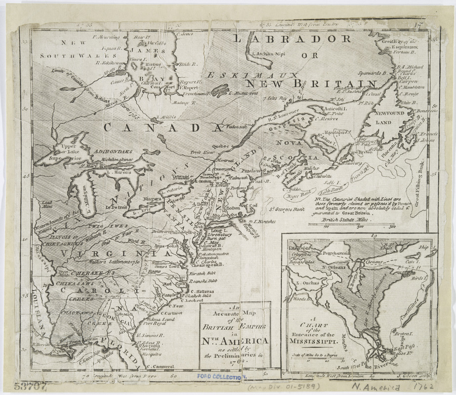
An accurate map of the British Empire in Nth. America as settled by the preliminaries in 1762
This map is also available in American Revolutionary Geographies Online (ARGO), a collections portal especially built for material relating to the American Revolutionary War Era. Visit ARGO to learn more about this item and explore the historical geography of North America in the late eighteenth century.
Item Information
- Title:
- An accurate map of the British Empire in Nth. America as settled by the preliminaries in 1762
- Title (alt.):
-
Accurate map of the British Empire in North America as settled by the preliminaries in 1762
- Title (uniform):
-
Gentleman's magazine (London, England)
- Creator:
- Gibson, J. (John), active 1750-1792
- Name on Item:
-
J. Gibson, sculp.
- Date:
-
[1762]
- Format:
-
Maps/Atlases
- Location:
- New York Public Library
- Collection (local):
-
Lawrence H. Slaughter Collection of English maps, charts, globes, books and atlases
- Subjects:
-
North America--Maps--Early works to 1800
Great Britain--Colonies--America--Maps--Early works to 1800
- Places:
-
North America (area)
- Extent:
- 1 map : hand col. ; 20 x 24 cm.
- Terms of Use:
-
No known copyright restrictions.
This work is licensed for use under a Creative Commons Attribution Non-Commercial Share Alike License (CC BY-NC-SA).

- Publisher:
-
London :
[s.n.]
- Scale:
-
Scale [ca. 1:15,000,000]
- Language:
-
English
- Catalog Record:
-
https://digitalcollections.nypl.org/items/510d47df-f910-a3d9-e040-e00a18064a99
- Notes:
-
Relief shown pictorially.
"Longitude west from London" and "Longitude west from Ferro."
In upper right margin: Gent. Mag.
From: Gentleman's magazine, v. 32, Dec. 1762.
Includes note and inset, "A chart of the entrance of the Mississippi."
- Notes (date):
-
This date is inferred.


