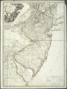
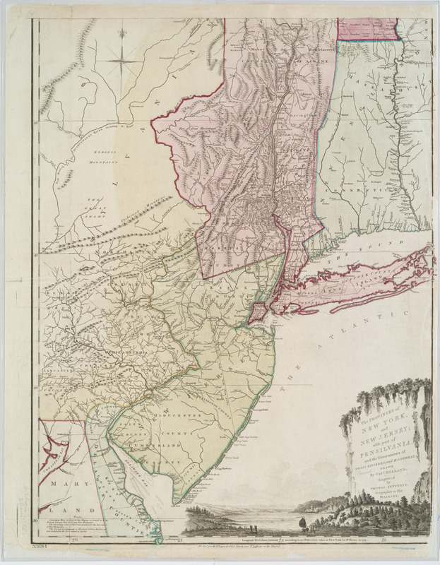
The provinces of New York, and New Jersey; with part of Pensilvania, and the governments of Trois Rivières, and Montreal
This map is also available in American Revolutionary Geographies Online (ARGO), a collections portal especially built for material relating to the American Revolutionary War Era. Visit ARGO to learn more about this item and explore the historical geography of North America in the late eighteenth century.
Item Information
- Title:
- The provinces of New York, and New Jersey; with part of Pensilvania, and the governments of Trois Rivières, and Montreal
- Title (alt.):
-
Chorographical map of the country between Albany, Oswego, Fort Frontenac, and les Trois Rivières
- Creator:
- Holland, Samuel, 1728-1801
- Contributor:
- Jefferys, Thomas, -1771
- Contributor:
- Sayer, Robert, 1725-1794
- Name on Item:
-
Drawn by Capt. Holland. Engraved by Thomas Jefferys, geographer to His Majesty.
- Date:
-
[1768?]
- Format:
-
Maps/Atlases
- Location:
- New York Public Library
- Collection (local):
-
Lawrence H. Slaughter Collection of English maps, charts, globes, books and atlases
- Subjects:
-
New York (State)--Maps--Early works to 1800
New York (State)--Administrative and political divisions--Maps--Early works to 1800
New Jersey--Maps--Early works to 1800
New Jersey--Administrative and political divisions--Maps--Early works to 1800
- Places:
-
New Jersey
New York
- Extent:
- col. map 135 x 52 cm.
- Terms of Use:
-
No known copyright restrictions.
This work is licensed for use under a Creative Commons Attribution Non-Commercial Share Alike License (CC BY-NC-SA).

- Publisher:
-
[London] :
Printed for Robt. Sayer ... and T. Jefferys
- Scale:
-
Scale ca. 1:650,000
- Language:
-
English
- Catalog Record:
-
https://digitalcollections.nypl.org/items/510d47df-faa1-a3d9-e040-e00a18064a99
- Notes:
-
Title in upper margin: A chorographical map of the country between Albany, Oswego, Fort Frontenac, and les Trois Rivières ... Drawn from authentic surveys by Thomas Jefferys, geographer to His Majesty.
Hand colored.
Prime meridian: London.
Relief shown pictorially.
Annotated on verso: Holland's map of New York & New Jersey, with part of Pennsylvania extending N. & South from Cape Hen[lo]pen to Lat. 46°40ʹ.
Shows administrative divisions.
Includes "Note."
- LCCN:
-
74692648