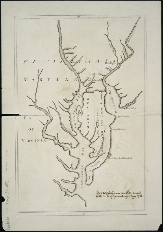
Lord Baltimore's own plan : proposed Maryland/Pennsylvania boundary
This map is also available in American Revolutionary Geographies Online (ARGO), a collections portal especially built for material relating to the American Revolutionary War Era. Visit ARGO to learn more about this item and explore the historical geography of North America in the late eighteenth century.
Item Information
- Title:
- Lord Baltimore's own plan : proposed Maryland/Pennsylvania boundary
- Creator:
- Senex, John, -1740
- Contributor:
- Baltimore, Charles Calvert, Baron, 1699-1751
- Date:
-
[1735?]
- Format:
-
Maps/Atlases
- Location:
-
New York Public Library
Lionel Pincus & Princess Firyal Map Division - Collection (local):
-
New York Public Library Collection
- Subjects:
-
Maryland--Boundaries--Pennsylvania--Maps--Early works to 1800
Pennsylvania--Boundaries--Maryland--Maps--Early works to 1800
Chesapeake Bay Region (Md. and Va.)--Maps--Early works to 1800
- Places:
-
Pennsylvania
Chesapeake Bay
Maryland
- Extent:
- 1 map ; 37 x 24 cm.
- Terms of Use:
-
No known copyright restrictions.
This work is licensed for use under a Creative Commons Attribution Non-Commercial Share Alike License (CC BY-NC-SA).

- Place of origin:
-
[London?]
- Scale:
-
Scale not given
- Language:
-
English
- Catalog Record:
-
https://digitalcollections.nypl.org/items/510d47db-b1bb-a3d9-e040-e00a18064a99
- Notes:
-
Author attribution and title based on Papenfuse & Coale as well as Maryland State Archives descriptions.
Endorsed in the bottom right corner inside the border, ms., in ink: This is Lord Baltimore's own plan, annext to the Articles of Agreement of 10 May 1732.
Described in the Maryland State Archives Web site at http://www.mdarchives.state.md.us/msa/speccol/1399/reports/html/260s5.html.
- Notes (citation):
-
Papenfuse & Coale. Hammond-Harwood House atlas of historical maps of Maryland, 1608-1908, figure 41
- Identifier:
-
478186

![Plan of the peninsula of Chesopeak [sic] Bay](https://bpldcassets.blob.core.windows.net/derivatives/images/commonwealth:z603vn14c/image_thumbnail_300.jpg)
