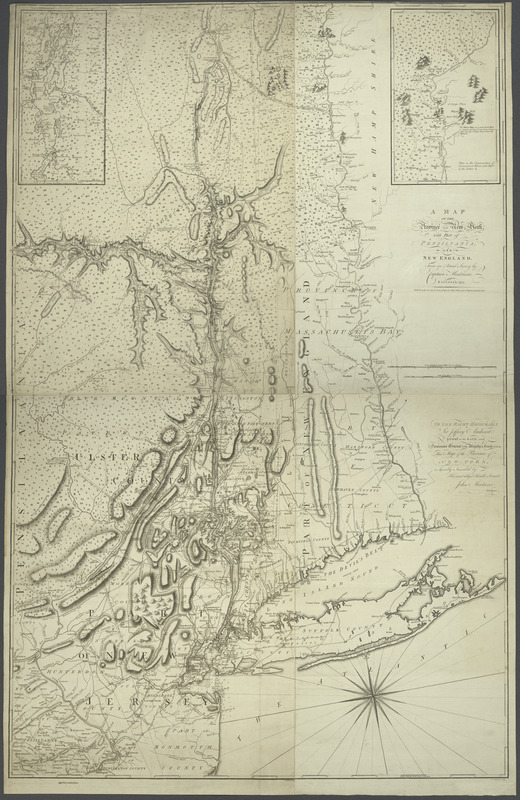
A map of the Province of New York, with part of Pensilvania, and New England : from an actual survey by Captain Montresor, engineer, 1775
This map is also available in American Revolutionary Geographies Online (ARGO), a collections portal especially built for material relating to the American Revolutionary War Era. Visit ARGO to learn more about this item and explore the historical geography of North America in the late eighteenth century.
Item Information
- Title:
- A map of the Province of New York, with part of Pensilvania, and New England : from an actual survey by Captain Montresor, engineer, 1775
- Description:
-
Inset maps: Continuations of Lake Champlain and the Connecticut River.
- Creator:
- Montrésor, John, 1736-1799
- Contributor:
- Andrews, Peter, active 1765-1782
- Contributor:
- Dury, Andrew
- Contributor:
- Amherst, Jeffery Amherst, Baron, 1717-1797
- Date:
-
[1777]
- Format:
-
Maps/Atlases
- Location:
- New York Public Library
- Collection (local):
-
Maps of New York City and State
- Subjects:
-
New York (State)--Maps--Early works to 1800
New England--Maps--Early works to 1800
Northeastern States--Maps--Early works to 1800
- Places:
-
New England (area)
New York
Northeastern United States (area)
- Extent:
- 1 map : col. ; 146 x 93 cm., on 2 sheets 74 x 94 cm. and 73 x 94 cm.
- Terms of Use:
-
No known copyright restrictions.
This work is licensed for use under a Creative Commons Attribution Non-Commercial Share Alike License (CC BY-NC-SA).

- Publisher:
-
London :
A. Dury ...
- Edition:
- Republished, with great improvements, Apr., 1st 1777
- Scale:
-
Scale ca. 1:320,000
- Language:
-
English
- Catalog Record:
-
https://digitalcollections.nypl.org/items/510d47db-c6b7-a3d9-e040-e00a18064a99
- Notes:
-
Relief shown pictorially and by hachures.
Shows administrative divisions.
Prime meridian: London.
Engraved by P. Andrews.
Hand colored.
2nd issue.
"Published ... June 10th 1775 by A. Dury, Dukes Court, St. Martins Lane, London. Republished with great improvements, April 1st, 1777."
"To the Right Honourable Sir Jeffery Amherst, this map of the Province of New York is humbly inscribed by his most obliged humble servant, John Montresor, engineer."
"Scale of British statute miles, 69 1/2 to a degree. Scale of leagues, 20 to a degree."
Appears in William Faden's The North American Atlas. 1777.
Montresor was one of the most active and wide-ranging military engineers operating in America in the period spanning the French and Indian War and the American Revolution. This map is his largest scope map and is considered one of the most detailed maps of New York issued during the Revolutionary era.
- Notes (date):
-
This date is inferred.
- LCCN:
-
74692645


