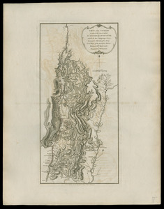
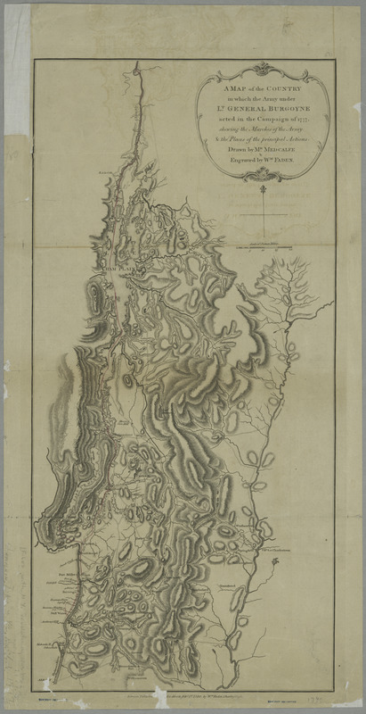
A map of the country in which the army under Lt. General Burgoyne acted in the campaign of 1777 : shewing the marches of the army & the places of the principal actions
This map is also available in American Revolutionary Geographies Online (ARGO), a collections portal especially built for material relating to the American Revolutionary War Era. Visit ARGO to learn more about this item and explore the historical geography of North America in the late eighteenth century.
Item Information
- Title:
- A map of the country in which the army under Lt. General Burgoyne acted in the campaign of 1777 : shewing the marches of the army & the places of the principal actions
- Creator:
- Medcalfe, Mr
- Engraver:
- Faden, William, 1749-1836
- Name on Item:
-
Drawn by Mr. Medcalfe & engraved by Wm. Faden.
- Date:
-
1780
- Format:
-
Maps/Atlases
- Location:
- New York Public Library
- Collection (local):
-
Maps of North America
- Subjects:
-
Burgoyne's Invasion, 1777--Maps--Early works to 1800
Vermont--Maps--Early works to 1800
- Places:
-
Vermont
- Extent:
- col. map, 57 x 28 cm.
- Terms of Use:
-
No known copyright restrictions.
This work is licensed for use under a Creative Commons Attribution Non-Commercial Share Alike License (CC BY-NC-SA).

- Publisher:
-
London :
W. Faden
- Scale:
-
Scale ca. 1:640,000
- Language:
-
English
- Catalog Record:
-
https://digitalcollections.nypl.org/items/510d47da-ee3d-a3d9-e040-e00a18064a99
- Notes:
-
Hand colored.
Relief shown by hachures.
Has watermarks.
Second copy of sheet 1: complete set of maps at Faden, William [Maps of the expedition from Canada of Gen. Burgoyne]
- LCCN:
-
gm 71002204