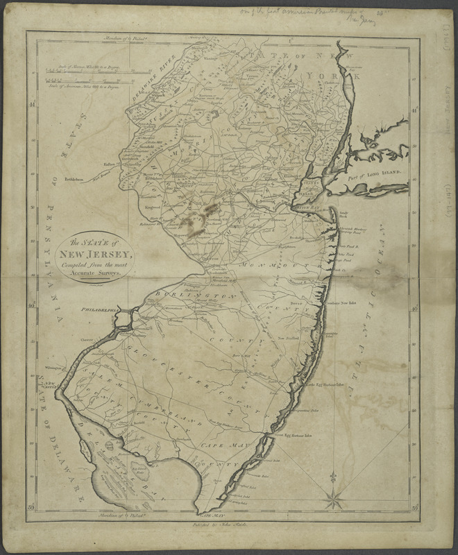
The State of New Jersey : compiled from the most accurate surveys
This map is also available in American Revolutionary Geographies Online (ARGO), a collections portal especially built for material relating to the American Revolutionary War Era. Visit ARGO to learn more about this item and explore the historical geography of North America in the late eighteenth century.
Item Information
- Title:
- The State of New Jersey : compiled from the most accurate surveys
- Title (alt.):
-
American atlas
- Engraver:
- Martin
- Contributor:
- Reid, John, publisher
- Name on Item:
-
Martin sculpt.
- Date:
-
[1796?]
- Format:
-
Maps/Atlases
- Location:
- New York Public Library
- Collection (local):
-
Maps of North America
- Subjects:
-
New Jersey--Maps--Early works to 1800
- Places:
-
New Jersey
- Extent:
- 1 map ; 44 x 34 cm.
- Terms of Use:
-
No known copyright restrictions.
This work is licensed for use under a Creative Commons Attribution Non-Commercial Share Alike License (CC BY-NC-SA).

- Publisher:
-
[New York] :
John Reid
- Scale:
-
Scale [ca. 1:600,000]
- Language:
-
English
- Catalog Record:
-
https://digitalcollections.nypl.org/items/510d47de-0fd7-a3d9-e040-e00a18064a99
- Notes:
-
Relief shown pictorially.
Appears in The American atlas. New-York : John Reid, [1796]. [No. 11].
"Meridian of Philad[elphi]a."

![An exact map of New Jersey, Pensylvania [sic], New York, Maryland & Virginia, from the latest surveys](https://bpldcassets.blob.core.windows.net/derivatives/images/commonwealth:z603vp67m/image_thumbnail_300.jpg)
![La Pensilvania, la Nuova York, il Jersey Settentrio[na]le](https://bpldcassets.blob.core.windows.net/derivatives/images/commonwealth:z603vq53g/image_thumbnail_300.jpg)

