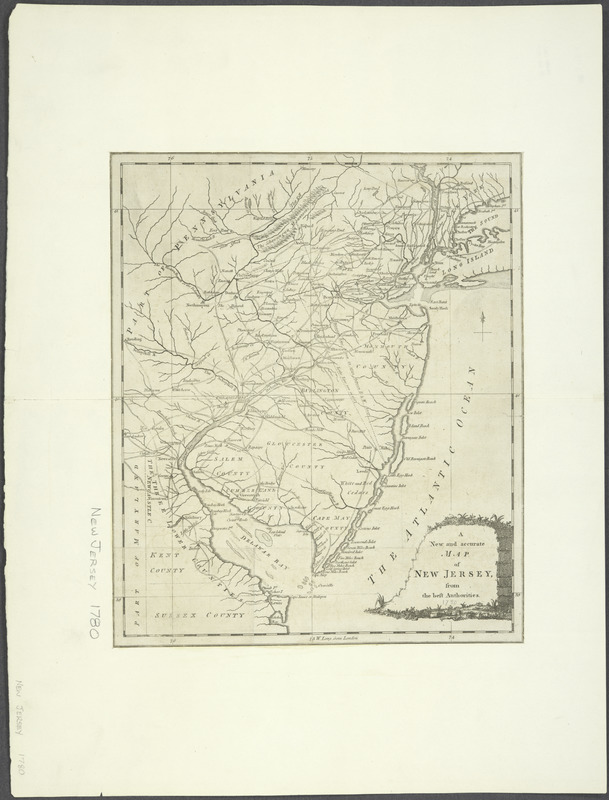
A New and accurate map of New Jersey : from the best authorities
This map is also available in American Revolutionary Geographies Online (ARGO), a collections portal especially built for material relating to the American Revolutionary War Era. Visit ARGO to learn more about this item and explore the historical geography of North America in the late eighteenth century.
Item Information
- Title:
- A New and accurate map of New Jersey : from the best authorities
- Contributor:
- Hinton, John, -1781
- Date:
-
[1780]
- Format:
-
Maps/Atlases
- Location:
- New York Public Library
- Collection (local):
-
Maps of North America
- Subjects:
-
New Jersey--Maps--Early works to 1800
- Places:
-
New Jersey
- Extent:
- 1 map ; 31 x 26 cm., on sheet 40 x 29 cm.
- Terms of Use:
-
No known copyright restrictions.
This work is licensed for use under a Creative Commons Attribution Non-Commercial Share Alike License (CC BY-NC-SA).

- Publisher:
-
London :
J. Hinton
- Scale:
-
Scale [ca. 1:900,000]
- Language:
-
English
- Catalog Record:
-
https://digitalcollections.nypl.org/items/510d47de-100b-a3d9-e040-e00a18064a99
- Notes:
-
Relief shown pictorially.
Title within ornamental cartouche.
From the Universal magazine, v. 66, June 1780.
"W. long. from London."
- Notes (date):
-
This date is inferred.

![An exact map of New Jersey, Pensylvania [sic], New York, Maryland & Virginia, from the latest surveys](https://bpldcassets.blob.core.windows.net/derivatives/images/commonwealth:z603vp67m/image_thumbnail_300.jpg)
![La Pensilvania, la Nuova York, il Jersey Settentrio[na]le](https://bpldcassets.blob.core.windows.net/derivatives/images/commonwealth:z603vq53g/image_thumbnail_300.jpg)


