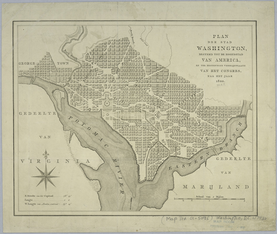
Plan der stad Washington : bestemd tot de hoofdstad van America, en ter bestendige verblijfplaats van het Congres, naa het jaar 1800
This map is also available in American Revolutionary Geographies Online (ARGO), a collections portal especially built for material relating to the American Revolutionary War Era. Visit ARGO to learn more about this item and explore the historical geography of North America in the late eighteenth century.
Item Information
- Title:
- Plan der stad Washington : bestemd tot de hoofdstad van America, en ter bestendige verblijfplaats van het Congres, naa het jaar 1800
- Creator:
- Kroe, A. van der
- Date:
-
[1793]
- Format:
-
Maps/Atlases
- Location:
- New York Public Library
- Collection (local):
-
Maps of North America
- Subjects:
-
Washington (D.C.)--Maps--Early works to 1800
Georgetown (Washington, D.C.)--Maps--Early works to 1800
- Places:
-
WashingtonGeorgetown
- Extent:
- 1 map ; 26 x 32 cm.
- Terms of Use:
-
No known copyright restrictions.
This work is licensed for use under a Creative Commons Attribution Non-Commercial Share Alike License (CC BY-NC-SA).

- Publisher:
-
Amsterdam :
[s.n.]
- Scale:
-
Scale [ca. 1:33,500]
- Language:
-
Dutch
- Catalog Record:
-
https://digitalcollections.nypl.org/items/510d47da-f07d-a3d9-e040-e00a18064a99
- Notes:
-
Shows proposed government buildings.
Relief shown by hachures.
Also covers Georgetown.
From A. van der Kroe's Vaderlandsche letter-oefeningen waarin boeken en schriften, Amsterdam, 1793, Z1007.V12.
Includes latitude/longitude statement.
- Notes (date):
-
This date is inferred.
- LCCN:
-
88694125