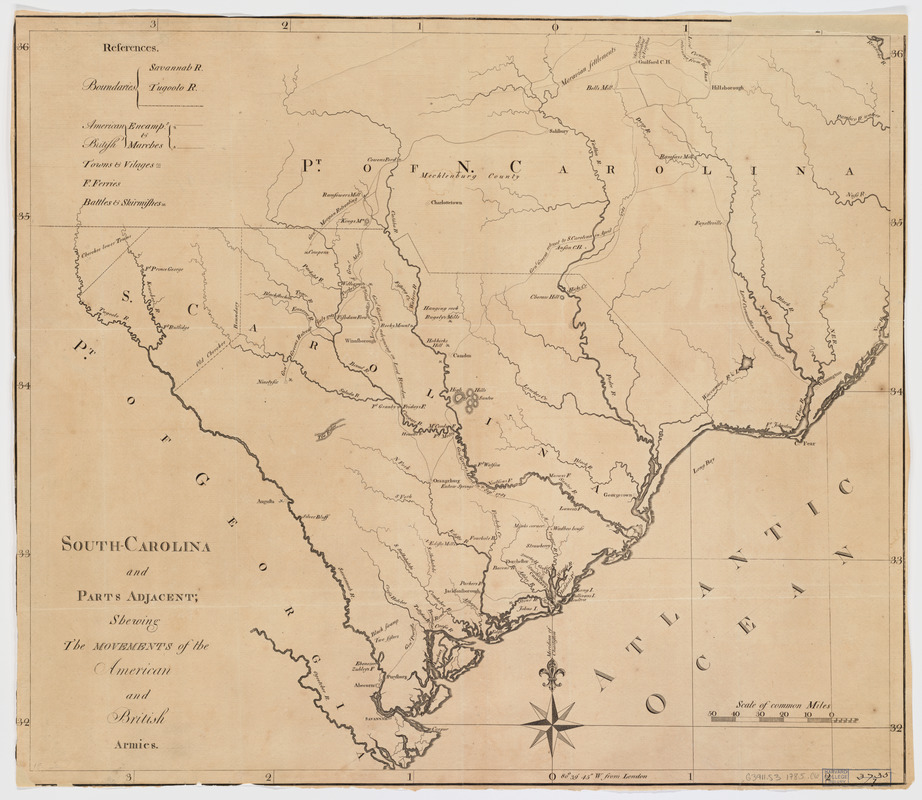
South-Carolina and parts adjacent : shewing the movements of the American and British armies
This map is also available in American Revolutionary Geographies Online (ARGO), a collections portal especially built for material relating to the American Revolutionary War Era. Visit ARGO to learn more about this item and explore the historical geography of North America in the late eighteenth century.
Item Information
- Title:
- South-Carolina and parts adjacent : shewing the movements of the American and British armies
- Title (alt.):
-
South Carolina and parts adjacent
- Creator:
- Collins, Isaac, 1746-1817
- Contributor:
- Ramsay, David, 1749-1815
- Date:
-
[1785]
- Format:
-
Maps/Atlases
- Location:
- Harvard Library
- Collection (local):
-
Harvard Map Collection
- Subjects:
-
South Carolina--History--Revolution, 1775-1783--Maps--Early works to 1800
North Carolina--History--Revolution, 1775-1783--Maps--Early works to 1800
- Places:
-
South Carolina
North Carolina
- Extent:
- 1 map ; 48 x 56 cm.
- Terms of Use:
-
No known copyright restrictions.
This work is licensed for use under a Creative Commons Attribution Non-Commercial Share Alike License (CC BY-NC-SA).

- Publisher:
-
Trenton, N.J :
Isaac Collins
- Scale:
-
Scale [ca. 1:1,025,000]
- Language:
-
English
- Catalog Record:
-
http://id.lib.harvard.edu/aleph/010152632/catalog
- Notes:
-
Shows state boundaries, names of towns, villiages, and cities, drainage, troop movements during 1781, batteries and skirmishes.
Also covers southcentral North Carolina.
Relief shown by hachures.
Appears in: History of the Revolution of South: from a British province to an independent state / by David Ramsay 1785. v. 2.
Prime meridian: London.
Includes list of references.
- Notes (date):
-
This date is inferred.