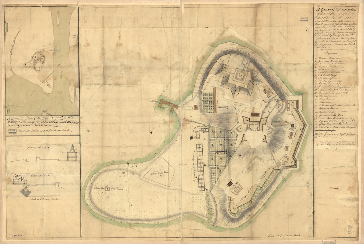
A general & particular plan of the island of Castle William near Boston : shewing the works in their original & present state, together with sections thro' the same. Carried on and survey'd under the direction of and by John Montrésor, Esqr., engineer extraordinary & Capt. Lieut. by order of the Honble: Thomas Gage, Esqr., Lieutenant General and Commander in Chief of His Majesty's forces in North America
This map is also available in American Revolutionary Geographies Online (ARGO), a collections portal especially built for material relating to the American Revolutionary War Era. Visit ARGO to learn more about this item and explore the historical geography of North America in the late eighteenth century.
Item Information
- Title:
- A general & particular plan of the island of Castle William near Boston : shewing the works in their original & present state, together with sections thro' the same. Carried on and survey'd under the direction of and by John Montrésor, Esqr., engineer extraordinary & Capt. Lieut. by order of the Honble: Thomas Gage, Esqr., Lieutenant General and Commander in Chief of His Majesty's forces in North America
- Title (alt.):
-
Castle William near Boston
- Creator:
- Montrésor, John, 1736-1799
- Date:
-
[1771?]
- Format:
-
Maps/Atlases
Manuscripts
- Location:
- Library of Congress Geography and Map Division
- Collection (local):
-
Library of Congress Geography and Map Division
- Subjects:
-
Fortification--Massachusetts--Castle Island--Maps--Early works to 1800
Manuscript maps
- Places:
-
Suffolk (county)Castle Island (cape)
- Extent:
- col. map; 76 x 115 cm.
- Terms of Use:
-
No known copyright restrictions.
This work is licensed for use under a Creative Commons Attribution Non-Commercial Share Alike License (CC BY-NC-SA).

- Scale:
-
Scale 1:600
- Language:
-
English
- Catalog Record:
-
https://lccn.loc.gov/gm71000936
- Notes:
-
Manuscript, pen-and-ink and watercolor.
Has watermarks.
Relief shown by shading.
Oriented with north toward the upper right.
Imperfect: Hole in center.
"No. 11."
Includes index to points of interest, inset of "A general plan of the island of Castle William shewing its situation with respect to the adjacent islands," 1:6,000, and two cross section views.
50 ft. to an in.
- LCCN:
-
gm 71000936


![Armstrong C[ount]y](https://bpldcassets.blob.core.windows.net/derivatives/images/commonwealth:q524ng353/image_thumbnail_300.jpg)

