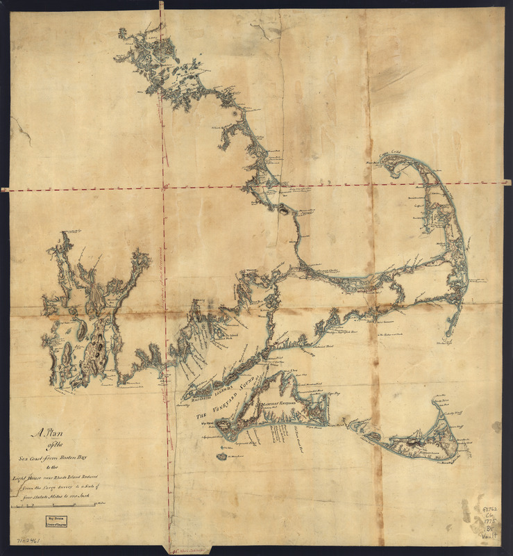
A plan of the sea coast from Boston Bay to the light house near Rhode Island : reduced from the large survey
This map is also available in American Revolutionary Geographies Online (ARGO), a collections portal especially built for material relating to the American Revolutionary War Era. Visit ARGO to learn more about this item and explore the historical geography of North America in the late eighteenth century.
Item Information
- Title:
- A plan of the sea coast from Boston Bay to the light house near Rhode Island : reduced from the large survey
- Title (alt.):
-
Sea coast from Boston Bay to the light house near Rhode Island
- Creator:
- Blaskowitz, Charles
- Date:
-
[1775?]
- Format:
-
Maps/Atlases
Manuscripts
- Location:
- Library of Congress Geography and Map Division
- Collection (local):
-
Library of Congress Geography and Map Division
- Subjects:
-
Coasts--Massachusetts--Maps--Early works to 1800
Coasts--Rhode Island--Maps--Early works to 1800
- Places:
-
Rhode Island
Massachusetts
- Extent:
- col. map on sheet 66 x 62 cm.
- Terms of Use:
-
No known copyright restrictions.
This work is licensed for use under a Creative Commons Attribution Non-Commercial Share Alike License (CC BY-NC-SA).

- Scale:
-
Scale 1:253,440
- Language:
-
English
- Catalog Record:
-
https://lccn.loc.gov/gm71002461
- Notes:
-
Manuscript, pen-and-ink and watercolor.
Relief shown by shading.
Has watermarks.
4 statute miles to 1 in.
- LCCN:
-
gm 71002461

![[Coast of New England from Chatham Harbor to Naragansett Bay]](https://bpldcassets.blob.core.windows.net/derivatives/images/commonwealth:7h149x27g/image_thumbnail_300.jpg)
![[Coast of New England from Chatham Harbor to Naragansett Bay]](https://bpldcassets.blob.core.windows.net/derivatives/images/commonwealth:7h149z37x/image_thumbnail_300.jpg)

![[Coast of Rhode Island and Long Island from Narragansett Bay to Peconic Bay]](https://bpldcassets.blob.core.windows.net/derivatives/images/commonwealth:7h149z14m/image_thumbnail_300.jpg)
