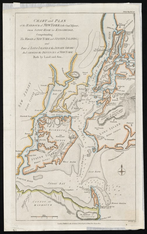
Chart and plan of the harbour of New York & the couny. adjacent, from Sandy Hook to Kingsbridge, comprehending the whole of New York and Staten Islands, and part of Long Island & the Jersey shore : and shewing the defences of New York both by land and sea
This map is also available in American Revolutionary Geographies Online (ARGO), a collections portal especially built for material relating to the American Revolutionary War Era. Visit ARGO to learn more about this item and explore the historical geography of North America in the late eighteenth century.
Item Information
- Title:
- Chart and plan of the harbour of New York & the couny. adjacent, from Sandy Hook to Kingsbridge, comprehending the whole of New York and Staten Islands, and part of Long Island & the Jersey shore : and shewing the defences of New York both by land and sea
- Creator:
- Lodge, John, -1796
- Contributor:
- Bew, John, -1793
- Name on Item:
-
Jno. Lodge, sculp.
- Date:
-
1781
- Format:
-
Maps/Atlases
- Location:
- Phillips Academy
- Collection (local):
-
Sidney R. Knafel Map Collection at Phillips Academy, Andover MA
- Subjects:
-
New York Harbor (NY and NJ)--History--Revolution, 1775-1783--Maps--Early works to 1800
New York (NY)--History--Revolution, 1775-1783--Maps--Early works to 1800
Manhattan (New York, NY)--History--18th century--Maps--Early works to 1800
Staten Island (New York, NY)--History--18th century--Maps--Early works to 1800
Long Island (NY)--History--Revolution, 1775-1783--Maps--Early works to 1800
New Jersey--History--Revolution, 1775-1783--Maps--Early works to 1800
Fortification--New York (State)--New York--Maps--Early works to 1800
- Places:
-
New York
New Jersey
- Extent:
- 1 map : hand colored ; 42 x 25 cm.
- Terms of Use:
-
Rights status not evaluated.
Contact host institution for more information.
- Publisher:
-
London :
J. Bew
- Scale:
-
Scale [ca. 1:150,000]
- Language:
-
English
- Notes:
-
Relief shown by hachures.
Depths shown by soundings.
"Political Mage. Novr. 1781."
From Political magazine, volume 2, opposite page 656.
"Published as the act directs Novr. 30th, 1781."
- Notes (citation):
-
Nebenzahl, Kenneth. Bibliography of printed battle plans, 104
- Identifier:
-
1444
- Call #:
-
Map 92.6.M5.1781