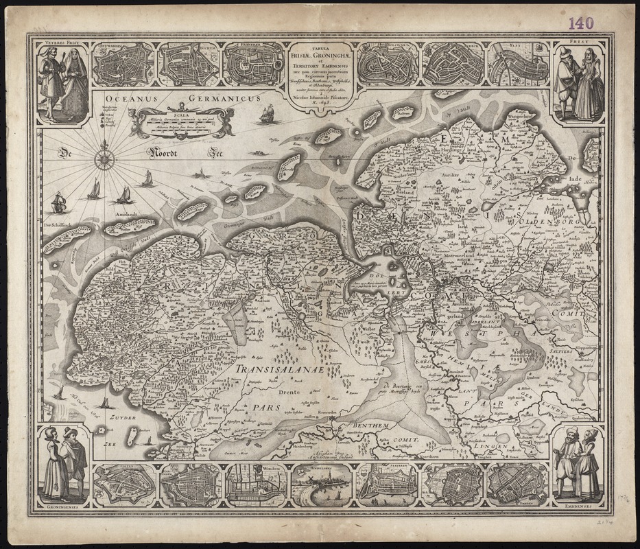
Tabula Frisiae, Groninghae, et Territory Embdensis nec non circum jacentium regionum puta Transisalaniae, Benthemiae, Westphaliae, et Oldenburgi, noviter summa cura et stidio edita
Item Information
- Title:
- Tabula Frisiae, Groninghae, et Territory Embdensis nec non circum jacentium regionum puta Transisalaniae, Benthemiae, Westphaliae, et Oldenburgi, noviter summa cura et stidio edita
- Creator:
- Visscher, Nicolaes, 1618-1679
- Name on Item:
-
à Nicolao Iohannide Piscatore.
- Date:
-
[1648]
- Format:
-
Maps/Atlases
- Location:
-
Boston Public Library
Norman B. Leventhal Map Center - Collection (local):
-
Norman B. Leventhal Map Center Collection
- Subjects:
-
Friesland (Netherlands)--Maps--Early works to 1800
Groningen (Netherlands : Province)--Maps--Early works to 1800
Lower Saxony (Germany)--Maps--Early works to 1800
- Places:
-
Friesland (province)
Lower Saxony
- Extent:
- 1 map ; 36 x 54 cm, on sheet 53 x 61 cm.
- Terms of Use:
-
No known copyright restrictions.
No known restrictions on use.
- Publisher:
-
Amsterdam :
N. VIsscher
- Scale:
-
Scale [ca. 1:450,000]
- Language:
-
Latin
- Notes:
-
Map of the Friesland and Groningen Provinces of the Netherlands, and the province of Lower Saxony in western Germany.
Includes thirteen city views and four illustrations of people in local costume.
Abraham Goos Amstelodamensis sculpsit.
Variant of maps described in Koeman, C. Atlantes Neerlandici, v. III, p. 176, no. [26].
Cataloging, conservation, and digitization made possible in part by The National Endowment for the Humanities: Exploring the human endeavor.
Part of composite portfolio atlas with title "Collection of old maps."
- Notes (date):
-
This date is inferred.
- Identifier:
-
06_01_009462
- Call #:
-
G1015 .C65 1630
- Barcode:
-
30000003860771
![Ducatus Brunsvicensis fere[que] Lunaeburgensis, cum adjacentibus Episcopatibus, Comit. Domin. etc., descriptio geographica](https://bpldcassets.blob.core.windows.net/derivatives/images/commonwealth:cj82kr74v/image_thumbnail_300.jpg)