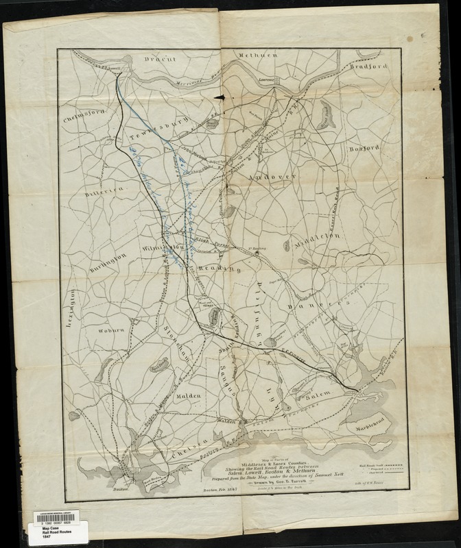
Map of parts of Middlesex & Essex counties showing the rail road routes between Salem, Lowell, Boston & Methuen
Item Information
- Title:
- Map of parts of Middlesex & Essex counties showing the rail road routes between Salem, Lowell, Boston & Methuen
- Creator:
- Parrott, George B.
- Engineer:
- Nott, Samuel
- Lithographer:
- Bouvé, Ephraim W., 1817-1897
- Name on Item:
-
prepared from the state map, under the direction of Samuel Nott drawn by Geo. B. Parrott.
- Date:
-
1847
- Format:
-
Maps/Atlases
- Location:
- Lucius Beebe Memorial Library
- Collection (local):
-
Lucius Beebe Memorial Library Historic Maps
- Subjects:
-
Railroads
- Places:
-
Essex (county)
Middlesex (county)
- Extent:
- 1 map ; 50 x 39 cm.
- Terms of Use:
-
No known copyright restrictions.
No known restrictions on use.
- Publisher:
-
Boston :
Lith of E.W. Bouvé
- Scale:
-
Scale [1:79,200]
- Language:
-
English
- Notes:
-
Covers also part of Suffolk County.
Map depicts parts of Essex and Middlesex counties, showing town boundaries, bodies of water, turnpikes and major town roads, and built and proposed rail road lines. Proposed lines are handcolored for emphasis.
- Notes (date):
-
"Feb. 1847."
- Call #:
-
Local History Map Case Rail Road Routes 1847
- Barcode:
-
31392003576828