Wakefield [Massachusetts] ; Greenwood ; Melrose
![Wakefield [Massachusetts] ; Greenwood ; Melrose](https://bpldcassets.blob.core.windows.net/derivatives/images/commonwealth:c534g400t/image_access_800.jpg)
Item Information
- Title:
- Wakefield [Massachusetts] ; Greenwood ; Melrose
- Date:
-
1874
- Format:
-
Maps/Atlases
- Location:
- Lucius Beebe Memorial Library
- Collection (local):
-
Lucius Beebe Memorial Library Historic Maps
- Places:
-
Middlesex (county)Melrose
Middlesex (county)WakefieldGreenwood
- Extent:
- 3 maps on 1 sheet : b&w with hand coloring ; 40 x 30 cm., 40 x 60 cm.
- Terms of Use:
-
No known copyright restrictions.
No known restrictions on use.
- Publisher:
-
[Wakefield] :
Geo. H. Walker & Co.
- Scale:
-
Scale 1:3,600 ; 1:14,400
- Language:
-
English
- Notes:
-
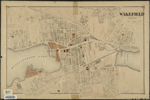
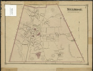
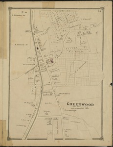
Map is presumed to be a sheet (pages 59-62) from an atlas of Middlesex County, published by George H. Walker of Boston.
Large map of downtown Wakefield covering central business district, Lake Quannapowitt, and Crystal Lake including Wakefield Rattan Company, Cyrus Wakefield estate, parks, cemeteries, and railroad lines. Stated scale is 400 feet to the inch. On verso are two smaller maps, one showing Melrose, and one showing Greenwood. The Greenwood map has a scale of approx. 300 feet to the inch. All three maps depict public and private buildings and names of property owners.
- Call #:
-
Local History Map Case Wakefield 1874
- Barcode:
-
31392003576984


