What's up? South! : world map
Item Information
- Title:
- What's up? South! : world map
- Title (alt.):
-
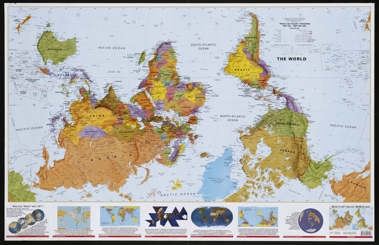
World map
What's up south
- Description:
-
A trilogy of maps distributed by a management consulting and publishing company in Amherst, Massachusetts, is an integral part of the company's mission to "honor differences" and to teach "people to see the world from a broader, more inclusive perspective." One of the most unusual is an upside down world map oriented with South at the top. Since world maps are generally oriented with North at the top of the page, this view point is shocking! It is not what most people expect to see and they inevitably ask why the map was printed incorrectly? The map obviously has a message to convey. During the past 500 years, the majority of map publishers were located in Europe and North America. By publishing North-oriented maps, they emphasized the geography of their own two continents, placing the others on the periphery. Such a secondary cartographic position also suggests that these continents were not as important economically or culturally. By creating a map with a totally opposite view point, the publishers are saying that there are other ways to look at the world. Their upside down perspective puts Africa in the center, flanked by Australia and South America. This orientation emphasizes the Third World countries, suggesting perhaps that they are also an important part of the world community and that we need to constantly reevaluate our perspectives.
- Creator:
- ODT, Inc
- Name on Item:
-
ODT, Inc.
- Date:
-
[ca. 2002]
- Format:
-
Maps/Atlases
- Location:
-
Boston Public Library
Norman B. Leventhal Map Center - Collection (local):
-
Norman B. Leventhal Map Center Collection
- Subjects:
-
World maps
- Places:
-
World
- Extent:
- 1 map : col. ; 92 x 143 cm.
- Terms of Use:
-
Under copyright.
All rights reserved.
- Publisher:
-
Amherst, Mass :
ODT
- Scale:
-
Scale 1:28,500,000. At equator ;
- Language:
-
English
- Notes:
-
Upside down world map as viewed from the North Pole.
Relief shown by spot heights, bathymetry, soundings, and shading.
Includes 7 ancillary maps showing map projections.
Exhibited in “Journeys of the Imagination,” at the Boston Public Library, Boston, MA, April - August 2006. MB (BRL)
- Identifier:
-
05_01_000239
- Call #:
-
G3200 2002 .O3
- Barcode:
-
39999059013811
- ISBN:
-
193105701X (laminated & tubed)
1931057028 (paper, folded)
1931057087 (paper, rolled)


