The population map
Item Information
- Title:
- The population map
- Title (alt.):
-
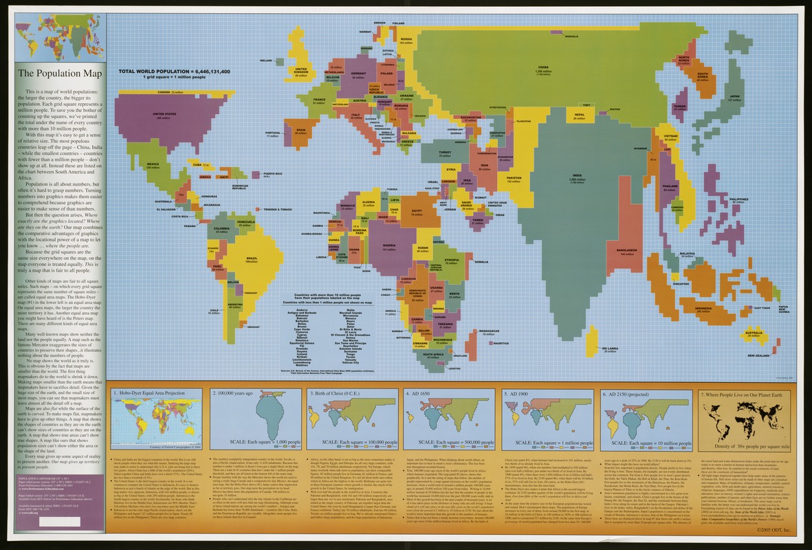
Total world population = 6,446,131,400
Population cartogram
- Description:
-
The most creative of the ODT trio is a world population map. This strange lego-like map is a cartogram, a diagram combining map and graph qualities. It distorts the size and shape of countries to portray their population (number of people) rather than their geographic territory (number of square miles). Since this is a map about people, it has a totally different appearance than conventional maps. China and India occupy the most space because they have the largest populations, while the United States and Indonesia vie for the third and fourth places. On the other hand, Russian Siberia and Canada, which cover large expanses of geographic territory, have much smaller populations and appear as narrow strips north of their much larger neighbors, China and the United States. The insets at the bottom of the map show the historical trends of population growth. There are snapshots showing population distributions by continent 100,000 years ago, at the birth of Christ, 1650 A.D., 1900 A.D., and a projection for 2150 A.D. This cartogram was compiled on a grid of small squares, where each square represents one million people. Although the countries are placed in their relative geographic locations, some unusual juxtapositions of geographic areas create a highly unconventional image of the world
- Creator:
- ODT, Inc
- Name on Item:
-
ODT ; Paul Breding.
- Date:
-
[ca. 2005]
- Format:
-
Maps/Atlases
- Location:
-
Boston Public Library
Norman B. Leventhal Map Center - Collection (local):
-
Norman B. Leventhal Map Center Collection
- Subjects:
-
Population--Maps
Population density--Maps
World maps
- Places:
-
World
- Extent:
- 1 map : col. ; 61 x 114 cm., on sheet 89 x 133 cm., originally folded to 30 x 23 cm.
- Terms of Use:
-
Under copyright.
All rights reserved.
- Publisher:
-
[Amherst, Mass.] :
ODT, Inc.
- Edition:
- Paper folded version.
- Scale:
-
Scale not given.
- Language:
-
English
- Table of Contents:
-
Total world population = 6,446,131,400
1. Hobo-Dyer Equal area projection [map]
2. 100,000 years ago
3. Birth of Christ (0 C.E.)
4. AD 1650
5. AD 1900
6. AD 2150 (projection)
7. Where people live on our planet earth.
- Notes:
-
1 grid square = 1 million people.
Includes 7 ancillary maps, text and unlabeled sample map.
Exhibited in “Journeys of the Imagination,” at the Boston Public Library, Boston, MA, April - August 2006. MB (BRL)
- Notes (exhibitions):
-
Exhibited: "Unconventional Maps: Exploring the Stories of Cartographic Curiosities" organized by the Norman B. Leventhal Map Center at the Boston Public Library, 2011-2012.
- Identifier:
-
05_01_000235
- Call #:
-
G3201.E24 2005 .O3
- Barcode:
-
39999052507314
- ISBN:
-
193105715X


