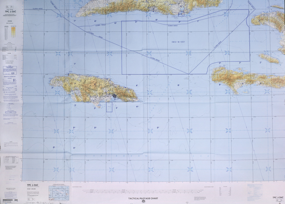
Tactical pilotage chart, TPC
Item Information
- Title:
- Tactical pilotage chart, TPC
- Title (alt.):
-
Cuba, Haiti, Jamaica, Navassa Island
TPC, Cuba, Haiti, Jamaica, Navassa Island
- Description:
-
This map, designed for use by air pilots, was printed by the military mapping agency, formerly known as the U.S. Defense Mapping Agency under its current name the National Imagery and Mapping Agency. As indicated by the marked-off "special use" airspace over Cuba and the U.S. Naval Base at Guantánamo Bay, this particular region of the Caribbean can be especially complicated for flight navigation to and from the United States. Navassa Island, located in the waters between Jamaica and Haiti was originally claimed in 1857 by the United States for mining operations. Since 1998, it has been recognized as an important oasis of Caribbean biodiversity and is protected as a National Wildlife Refuge.
- Creator:
- United States. National Imagery and Mapping Agency
- Name on Item:
-
prepared and published by the National Imagery and Mapping Agency
- Date:
-
[1997]
- Format:
-
Maps/Atlases
- Location:
-
Boston Public Library
Norman B. Leventhal Map Center - Collection (local):
-
Norman B. Leventhal Map Center Collection
- Subjects:
-
Aeronautical charts--Cuba
Aeronautical charts--Haiti
Aeronautical charts--Jamaica
Aeronautical charts--Navassa Island
Lambert conformal conic projection (Cartography)
Cuba--Maps
Haiti--Maps
Jamaica--Maps
Navassa Island--Maps
- Places:
-
Cuba
Haiti
Jamaica
Navassa Island (territory)
- Extent:
- 1 map : col. ; 105 x 145 cm.
- Terms of Use:
-
No known copyright restrictions.
No known restrictions on use.
- Publisher:
-
[St. Louis, Mo.?] ; Riverdale, MD :
Natinal Imagery and Mapping Agency ; NOAA Distribution Branch (N/ACC3), National Ocean Service [distributor
- Edition:
- Ed. 5.
- Scale:
-
Scale 1:500,000
- Language:
-
English
- Notes:
-
Relief shown by contours, shading, tints, and spot heights.
"Air information current through 13 May 1996."
"Compiled December 1969; revised October 1995."
"Lithographed by NIMA 2-97."
"Copyright 1997 by the United States Government. No copyright claimed under Title 17 U.S.C."
Includes elevation tints and interchart relationship diagrams.
Exhibited in “Faces and Places,” at the Boston Public Library, Boston, MA, October 2003 - September 2004.
- Notes (date):
-
This date is inferred.
- Identifier:
-
05_04_000185
- Barcode:
-
30000007463673