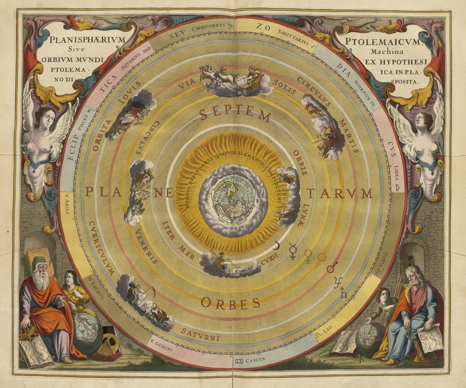
Planisphaerium Ptolemaicum siue machina orbium mundi ex hypothesi Ptolemaica in plano disposita
Item Information
- Title:
- Planisphaerium Ptolemaicum siue machina orbium mundi ex hypothesi Ptolemaica in plano disposita
- Title (alt.):
-
Planisphaerium Ptolemaicum sive machina orbium mundi ex hypothesi Ptolemaica in plano disposita
Planisphaerivm Ptolemaicvm sive machina orbivm mvndi ex hypothesi Ptolemaica in plano disposita
- Description:
-
While most of the maps in this exhibit depict just the Earth -- reflecting mankind's perception of his immediate and perceived environment -- very few address the planet's position in the larger universe. However, geographers, astronomers, and map makers during the Renaissance and Baroque periods were very interested in observing and mapping the heavenly bodies and theorizing about their relationship to the Earth. In the mid-17th century, Andreas Cellarius, a Dutch mathematician and geographer, compiled a lavish celestial atlas. This comprehensive book brought together numerous charts and a wealth of astronomical information from various sources. The initial chapters described the theories of several astronomers including Claudius Ptolemy, Nicolaus Copernicus, and Tycho Brahe. The later chapters discussed such subjects as the magnitudes of the stars, lunar and solar theories, the nature of the planets, and the constellations of the zodiac. These topics were illustrated with beautifully engraved and hand colored plates. One illustration included in Cellarius' book is this plate depicting the Earth-centered universe theorized by Claudius Ptolemy, the 2nd century A.D. geographer who lived in Alexandria, Egypt. At the center of this diagram, there is a small map of the Earth's northern hemisphere. Revolving around the Earth in separate orbits are the Moon, Mercury, Venus, the Sun, Mars, Jupiter, and Saturn. The outer circle was reserved for the stars, represented as the constellations of the zodiac. This was the prevailing theory of the universe until the mid-16th century when Copernicus proposed a solar system centered on the Sun.
- Creator:
- Cellarius, Andreas.
- Name on Item:
-
Andreas Cellarius.
- Date:
-
1661
- Format:
-
Maps/Atlases
- Location:
-
Boston Public Library
Norman B. Leventhal Map Center - Collection (local):
-
Norman B. Leventhal Map Center Collection
- Subjects:
-
World maps--Early works to 1800
Planets--Maps--Early works to 1800
Astronomy--Early works to 1800
Solar system--Maps--Early works to 1800
- Places:
-
World
- Extent:
- 1 map : col. ; 46 x 64 cm.
- Terms of Use:
-
No known copyright restrictions.
No known restrictions on use.
- Publisher:
-
Amsterdam :
[s.n.]
- Scale:
-
Scale not given.
- Language:
-
Latin
- Notes:
-
Appears in Cellarius' Harmonia macrocosmica, seu, Atlas... Amsterdam. 1661.
- Notes (exhibitions):
-
Exhibited in “Journeys of the Imagination,” at the Boston Public Library, Boston, MA, April, August 2006. MB (BRL)
Exhibited: "Unconventional Maps: Exploring the Stories of Cartographic Curiosities" organized by the Norman B. Leventhal Map Center at the Boston Public Library, 2011-2012.
Exhibited: "Crossing Boundaries: Art // Maps" organized by the Norman B. Leventhal Map Center at the Boston Public Library, 2018-2019.
- Identifier:
-
05_01_000248
- Call #:
-
QB41 .C39
- Barcode:
-
39999058997220


