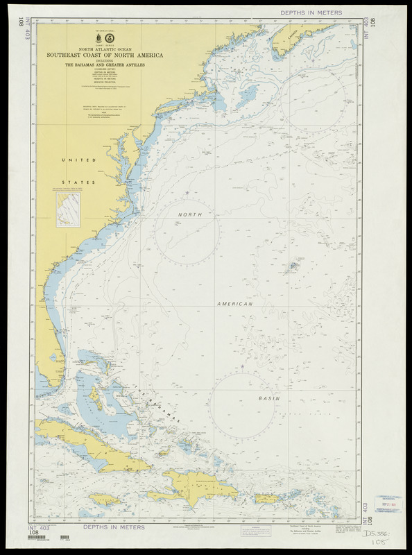
North Atlantic Ocean, southeast coast of North America, including the Bahamas and Greater Antilles
Item Information
- Title:
- North Atlantic Ocean, southeast coast of North America, including the Bahamas and Greater Antilles
- Title (alt.):
-
Southeast coast of North America, including the Bahamas and Greater Antilles
- Description:
-
This navigational chart, which is one sheet in the U.S. Defense Mapping Agency's world hydrographic chart series, shows the waters along the southeastern coast of the United States. In this part of the Atlantic Ocean, there is a warm ocean current, known as the Gulf Stream, which flows north from the Caribbean Sea along the east coast of the United States across the North Atlantic to Europe. Historically, the current provided the major route for European ships, especially Spanish galleons, returning from their Central American, Mexican, and West Indian colonies to Europe.
- Creator:
- United States. Defense Mapping Agency Hydrographic/Topographic Center
- Name on Item:
-
prepared and published by the Defense Mapping Agency Hydrographic/Topographic Center
- Date:
-
1994
- Format:
-
Maps/Atlases
- Location:
-
Boston Public Library
Norman B. Leventhal Map Center - Collection (local):
-
Norman B. Leventhal Map Center Collection
- Subjects:
-
Nautical charts--North Atlantic Ocean
North Atlantic Ocean--Navigation
Atlantic Coast (North America)--Maps
North Atlantic Ocean--Maps
- Places:
-
Atlantic Ocean
- Extent:
- 1 map : col. ; 107 x 78 cm.
- Terms of Use:
-
No known copyright restrictions.
No known restrictions on use.
- Publisher:
-
Bethesda, Md :
Defense Mapping Agency Hydrographic/Topographic Center
- Edition:
- 9th ed., Jan. 8, 1994 (Correct through NM 2/94).
- Scale:
-
Scale 1:3,500,000
- Language:
-
English
- Notes:
-
Title from physical map.
Relief shown by spot heights.
Depths shown by isolines and soundings.
"Depths in meters."
Includes inset map of 1990 magnetic variation curves in purple.
- Notes (exhibitions):
-
Exhibited: "Faces & Places" organized by the Norman B. Leventhal Map Center at the Boston Public Library, 2003-2004.
- Identifier:
-
06_01_000080
- Barcode:
-
30000007463675


