Carte du Mexique et de la Florida : des terres angloises et des Isles Antilles, du cours et des environs de la Riviere de Mississippi
Item Information
- Title:
- Carte du Mexique et de la Florida : des terres angloises et des Isles Antilles, du cours et des environs de la Riviere de Mississippi
- Title in upper margin :
- Tabula geographica Mexicae et Florida &c
- Description:
-
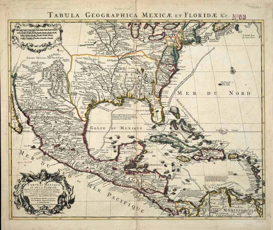
Guillaume de L'Isle, the most influential French mapmaker in the early 18th century, prepared a landmark map of North America in 1703, the first printed map to accurately plot the mouth and lower courses of the Mississippi River. The map displayed here is a 1722 reprinting of the original map by the Dutch firm of Covens and Mortier. Besides the interior part of North America portraying the Mississippi River and its tributaries, which was based on late 17th-century Spanish and French explorations, the map provides a fairly accurate depiction of the West Indies (including Cuba, Hispaniola, and Jamaica) as well as the Caribbean rimland (Mexico, Central America, and northern South America). A notable feature which does not appear on the original 1703 edition, is the delineation of the tracks of Spanish galleons showing their approach from Spain along the north coast of South America, with portions of the fleet going to Cartagena (present-day Colombia), Porto Bello (Panama), and Vera Cruz (Mexico). After loading their cargo, the ships returned to Havana (Cuba), where they congregated, sailing in mass north along the Florida coast, taking advantage of the Gulf Stream on the return voyage to Spain. Interestingly, these Spanish colonial shipping routes established patterns of interaction that have influenced 20th century migrations. Ironically, Florida, which was on the periphery of the Spanish empire and served only as a supply outpost for returning fleets, is now the magnet for immigration coming from the former the Spanish colonial empire.
- Creator:
- L'Isle, Guillaume de, 1675-1726
- Name on Item:
-
dressée sur un grand nombre de memoires principalement sur ceux de Mrs. d'Iberville et le sueur ... ; par Guillaume de l'Isle ; I. Stemmers, senior, sculp.
- Date:
-
1722
- Format:
-
Maps/Atlases
- Location:
-
Boston Public Library
Norman B. Leventhal Map Center - Collection (local):
-
Norman B. Leventhal Map Center Collection
- Subjects:
-
North America--Maps--Early works to 1800
- Places:
-
North America (area)
- Extent:
- 1 map : col. ; 54 x 64 cm.
- Terms of Use:
-
No known copyright restrictions.
No known restrictions on use.
- Publisher:
-
Amsterdam :
Chez Jean Covens & Corneille Mortier
- Scale:
-
Scale [ca. 1:9,750,000]
- Language:
-
French
- Notes:
-
Relief shown pictorially.
Prime meridian: Ferro.
Featured in the Faces & Places Exhibit, Kravis Center, Palm Beach, FL, since 2005. MB (BRL)
- Identifier:
-
05_04_000116
- Call #:
-
G3300 1722 .L5
- Barcode:
-
39999052509294


