Amérique Septentrionale
Item Information
- Title:
- Amérique Septentrionale
- Description:
-
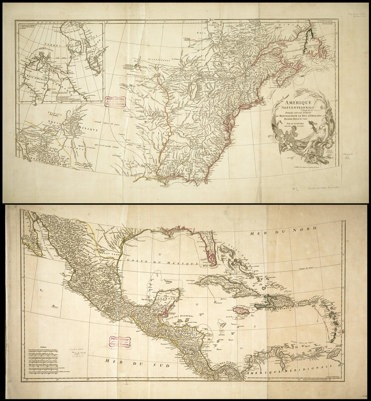
D'Anville, the French royal geographer during the mid-18th century, compiled over 200 maps, including this one of North America. Although this particular copy is dated 1746 reflecting the map's original publication, it must have been issued after 1763 since the coloring delineates boundaries established at the conclusion of the French and Indian War. Prior to the war, France claimed an extensive empire in the interior parts of North America. These possessions, which were only sparsely occupied primarily by fur traders in alliance with the Indians, extended in an arc from the Gulf of St. Lawrence through the Great Lakes to the Gulf of Mexico. The settled areas were concentrated in Acadia, Canada, Illinois, and southern Louisiana. According to the provisions of the Paris Peace Treaty (1763), England took control of the French lands east of the Mississippi River and north to Hudson Bay, while Spain claimed the lands west of the Mississippi River. France's remaining possessions, which were colored red on the map, were located in the Caribbean and included Haiti, Guadeloupe, and Martinique.
- Creator:
- Anville, Jean Baptiste Bourguignon d', 1697-1782
- Cartographer:
- Anville, Jean Baptiste Bourguignon d', 1697-1782
- Name on Item:
-
publiée sous les auspices de Monseigneur le Duc d'Orleans, prémier prince du sang ; par le Sr. d'Anville
- Date:
-
1746
- Format:
-
Maps/Atlases
- Location:
-
Boston Public Library
Norman B. Leventhal Map Center - Collection (local):
-
Norman B. Leventhal Map Center Collection
- Subjects:
-
North America--Maps--Early works to 1800
- Places:
-
North America (area)
- Extent:
- 1 map : col. ; 83 x 86 cm.
- Terms of Use:
-
No known copyright restrictions.
No known restrictions on use.
- Publisher:
-
Paris :
chez l'auteur
- Scale:
-
Scale [ca. 1:6,340,000]
- Language:
-
French
- Notes:
-
Relief shown pictorially.
Hand colored.
This map is particulary distinctive for its portrayal of the Mississippi River valley and the river systems between the St. Lawrence and James Bay.
Featured in the Faces & Places Exhibit, Kravis Center, Palm Beach, FL, since 2005.
- Identifier:
-
05_04_001002
- Call #:
-
G3300 1746 .A5
- Barcode:
-
39999052509286


