America Septentrionalis : concinnata juxta observationes Dnn Academiae Regalis Scientiarum et nonnullorum aliorum, et juxta annotationes recentissimas
This map is also available in American Revolutionary Geographies Online (ARGO), a collections portal especially built for material relating to the American Revolutionary War Era. Visit ARGO to learn more about this item and explore the historical geography of North America in the late eighteenth century.
Item Information
- Title:
- America Septentrionalis : concinnata juxta observationes Dnn Academiae Regalis Scientiarum et nonnullorum aliorum, et juxta annotationes recentissimas
- Description:
-
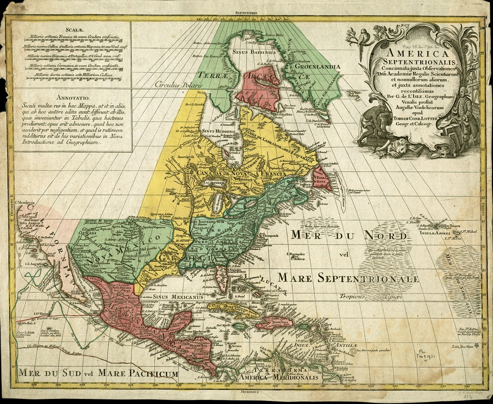
The third map in this sequence is another derivative of Delisle's 1703 North American map, as is acknowledged in the title cartouche. However, this map, published by another German cartographer, shows significant differences from the previous two maps. Not only has the map been redrawn showing different island and land mass configurations (compare the shape of Florida), but also the extent of political control has changed dramatically. While the map is undated, it was apparently published in the middle of the 18th century, since it portrays a greater British presence, reflecting British territorial gains following the defeat of the French and their Spanish ally in the French and Indian War. The entire eastern portion of the continent south of the St. Lawrence River extending west to the Mississippi River is British (green), except for the solitary Florida peninsula. An indication of the diminished Spanish influence in the Caribbean is the removal of the tracts of the Spanish galleons, only to be replaced by the tracks of several British and Dutch navigators, including Sir Francis Drake, along the Pacific Coast of North America.
- Creator:
- Lotter, Tobias Conrad, 1717-1777
- Name on Item:
-
per G. de L'Isle, geographum venalis prostat Augustae Vindelicorum ; Tobias Conr. Lotter.
- Date:
-
[1758]
- Format:
-
Maps/Atlases
- Location:
-
Boston Public Library
Norman B. Leventhal Map Center - Collection (local):
-
Norman B. Leventhal Map Center Collection
- Subjects:
-
North America--Maps--Early works to 1800
- Places:
-
North America (area)
- Extent:
- 1 map : col. ; 60 x 49 cm.
- Terms of Use:
-
No known copyright restrictions.
No known restrictions on use.
- Publisher:
-
Augsburg :
s.n.
- Scale:
-
Scale not given.
- Language:
-
Latin
- Notes:
-
Relief shown pictorially.
Featured in the Faces & Places Exhibit, Kravis Center, Palm Beach, FL, since 2005. MB (BRL)
- Notes (date):
-
This date is inferred.
- Identifier:
-
05_04_000112
- Call #:
-
G3300 1758 .L68
- Barcode:
-
39999052509278


