A new and accurate chart of the West Indies : with the adjacent coasts of North and South America
This map is also available in American Revolutionary Geographies Online (ARGO), a collections portal especially built for material relating to the American Revolutionary War Era. Visit ARGO to learn more about this item and explore the historical geography of North America in the late eighteenth century.
Item Information
- Title:
- A new and accurate chart of the West Indies : with the adjacent coasts of North and South America
- Description:
-
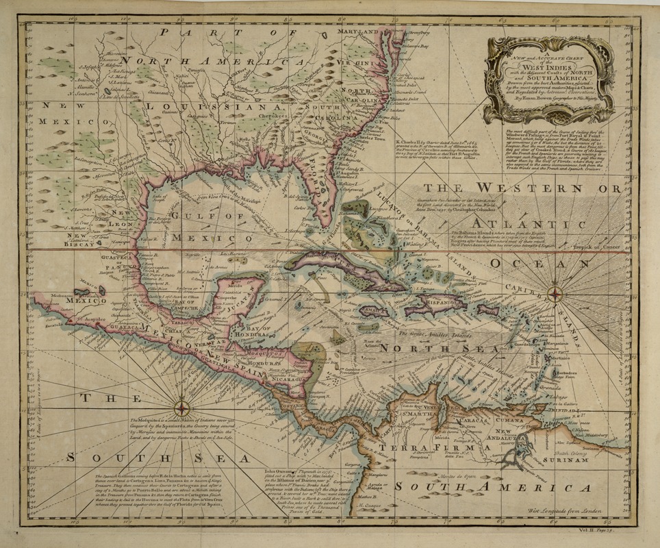
This chart was published in John Harris's "Navigantium atque Itinerantium Bibliotheca, or A Complete Collection of Voyages and Travels". Although the chart also includes the eastern coast of the Americas, its main function was to aid in the navigation through the Caribbean Sea and around the West Indian islands. Currents were indicated by arrows and deeper waters by darker shading. The text scattered throughout the map is primarily historical in nature, mentioning, for example, Columbus' landing in San Salvador, and the British annexation of the Bahamas in 1707. Navigational advice was also provided, as well as a detailed description of how to carry cargo overland across Central America from "the South Sea" (the Pacific) to the "North Sea" (the Caribbean) and back to Europe. "Inconveniences" along the trade routes included rough trade winds and pirates.
- Creator:
- Bowen, Emanuel, d. 1767
- Name on Item:
-
Drawn from the best authorities ... by Eman. Bowen.
- Date:
-
1748
- Format:
-
Maps/Atlases
- Location:
-
Boston Public Library
Norman B. Leventhal Map Center - Collection (local):
-
Norman B. Leventhal Map Center Collection
- Subjects:
-
Caribbean Area--Maps--Early works to 1800
West Indies--Maps--Early works to 1800
- Places:
-
West Indies
Caribbean Sea
- Extent:
- 1 map : col. ; 45 x 37 cm.
- Terms of Use:
-
No known copyright restrictions.
No known restrictions on use.
- Publisher:
-
London :
John Harris
- Scale:
-
Scale not given.
- Language:
-
English
- Notes:
-
Relief shown pictorially.
Includes the coasts of North, America, Central America and South America.
Includes historical descrptions of areas presented.
Exhibited in “Faces and Places,” at the Boston Public Library, Boston, MA, October 2003 - September 2004. MB (BRL)
- Identifier:
-
05_04_000142
- Call #:
-
G4900 1748 .B69
- Barcode:
-
39999052507850


