Carte geographique de la Nouvelle Franse
Item Information
- Title:
- Carte geographique de la Nouvelle Franse
- Title (alt.):
-
Carte geographiqve de la Novvelle Franse
- Creator:
- Champlain, Samuel de, 1574-1635
- Cartographer:
- Champlain, Samuel de, 1574-1635
- Printer:
- Berjon, Jean
- Engraver:
- Pelletier, David
- Name on Item:
-
faictte par le sieur de Champlain, Saint Tongois cappitaine ordinaire pour le roy en la marine ; David pelletier fecit
- Date:
-
1613
- Format:
-
Maps/Atlases
- Location:
-
Boston Public Library
Norman B. Leventhal Map Center - Collection (local):
-
Norman B. Leventhal Map Center Collection
- Subjects:
-
North America--Maps--Early works to 1800
New France--Maps--Early works to 1800
Saint Lawrence River Valley--Maps--Early works to 1800
- Places:
-
New France
- Extent:
- 1 map ; 35 x 77 cm, on sheet 45 x 79 cm
- Terms of Use:
-
No known copyright restrictions.
No known restrictions on use.
- Publisher:
-
[A Paris] :
[Chez Iean Berjon, rue S. Iean de Beauuais, au Cheual volant, & en sa boutique au Palais, {grave}a la gallerie de prisonniers]
- Scale:
-
Scale approximately 1:5,500,000
- Language:
-
French
- Notes:
-
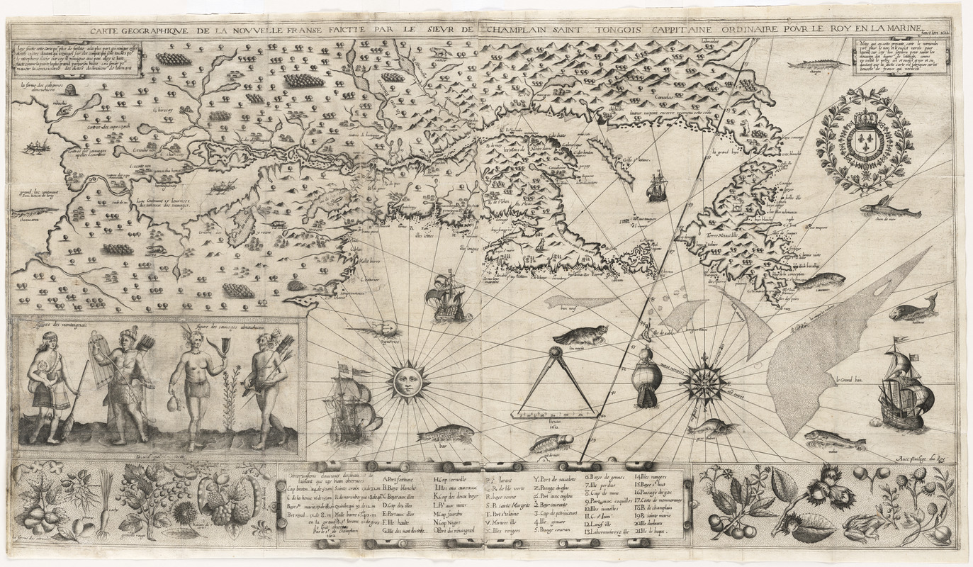
This map is designated in honor of Ronald E. Grim Ph.D. in acknowledgement of his extraordinary contributions to the Norman B. Leventhal Map Center as Curator of Maps from 2005-2018. The map holds a special place in our hearts, as Ron recovered it through his vigilance and expertise after it was absent from the collection for 10 years. It will forever remind us of his presence here.
Detached from: Les voyages du sieur de Champlain Xaintongeois, capitaine ordinaire pour le roy en la marine. Paris : Iean Berjon, 1613.
"Faict len 1612."
"Avec privilege du roy."
Partly based on information supplied by Indians. Compare Burden, 160.
Relief shown pictorially.
Oriented with north at upper right.
Table showing declination of the sun at 9 locations and key to references A-T, V, X-Z, and [1]-21 in bottom margin.
Includes portrait (11 x 23 cm) of 4 Indian men of the Montaignais and Almonichicois tribes in native costume and scattered illustrations of native vegetation and wildlife; sea decorated with ships and marine wildlife.
Details the region surrounding the Saint Lawrence River Valley westward to the eastern end of Lake Erie; shows settlements and Indian villages.
- Notes (citation):
-
Buisseret, D. Mapping the French empire in North America, page 9, number 4
Burden, P.D. Mapping of North America, I, page 197-198, number 160
Cumming, Skelton & Quinn. Discovery of North America, page 273 and figure 338
- Identifier:
-
06_01_015039
- Call #:
-
F1030.1 .C43 1613
- Barcode:
-
39999085930350


