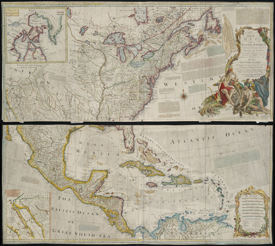
An accurate map of North America : describing and distinguishing the British and Spanish dominions on this great continent : according to the definitive treaty concluded at Paris 10th Feby. 1763 : also all the West India Islands belonging to, and possessed by the several European princes and states
Item Information
- Title:
- An accurate map of North America : describing and distinguishing the British and Spanish dominions on this great continent : according to the definitive treaty concluded at Paris 10th Feby. 1763 : also all the West India Islands belonging to, and possessed by the several European princes and states
- Creator:
- Bowen, Emanuel, d. 1767
- Contributor:
- Gibson, John
- Contributor:
- Sayer, Robert, 1725-1794
- Name on Item:
-
the whole laid down according to the latest and most authentick improvements, by Eman. Bowen, geogr. to His Majesty, and John Gibson, engraver
- Date:
-
1772
- Format:
-
Maps/Atlases
- Location:
- Private Collection
- Collection (local):
-
Mapping Boston Collection
- Subjects:
-
North America--Maps--Early works to 1800
- Places:
-
North America (area)
- Extent:
- 1 map : col. ; 116 x 53 cm.
- Terms of Use:
-
No known copyright restrictions.
This work is licensed for use under a Creative Commons Attribution Non-Commercial Share Alike License (CC BY-NC-SA).

- Publisher:
-
London :
Printed for Robert Sayer
- Scale:
-
Scale [ca. 1:550,000]
- Language:
-
English
- Notes:
-
Third state.
Relief shown pictorially.
Hand colored.
"Longit. w. from Ferro."
Includes historical notes, notes on territorial claims, and insets of "A particular map of Baffin and Hudson's Bay" and "The passage by land to California."
Featured in the Faces & Places Exhibit, Kravis Center, Palm Beach, FL, 2005.
- Identifier:
-
06_01_001286
- Barcode:
-
39999085930442


