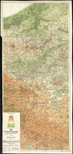
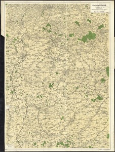
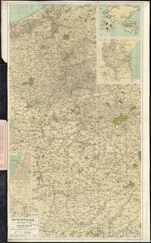
The Daily Telegraph war map no. 24 : of the British front
Item Information
- Title:
- The Daily Telegraph war map no. 24 : of the British front
- Title (alt.):
-
Daily telegraph war map of the British front (no. 24)
- Title (uniform):
-
Daily telegraph (London, England)
- Creator:
- Gross, Alexander, 1879-1958
- Name on Item:
-
by Alexander Gross ; produced by "Geographia" Ltd.
- Date:
-
[1917]
- Format:
-
Maps/Atlases
- Location:
-
Boston Public Library
Norman B. Leventhal Map Center - Collection (local):
-
Norman B. Leventhal Map Center Collection
- Subjects:
-
World War, 1914-1918--France--Maps
World War, 1914-1918--Belgium--Maps
France--Maps
Belgium--Maps
- Places:
-
France
Belgium
- Extent:
- 1 map : color ; 97 x 56 cm, folded in cover 21 x 13 cm.
- Terms of Use:
-
No known copyright restrictions.
No known restrictions on use.
- Publisher:
-
London :
"Geographia" Ltd.
- Scale:
-
Scale approximately 1:174,000
- Language:
-
English
- Notes:
-
Shows fighting lines before the July 1st, 1916 advance and approximate fighting line on July 1st, 1917.
Relief shown by spot heights.
Covers the region between Lille and St. Quentin in northern France and West Flanders, Belgium.
Insets: German colonies before the war -- East Africa, German colony before the war -- Palestine -- Salonika district.
- Notes (date):
-
This date is inferred.
- Identifier:
-
06_01_012267
- Call #:
-
G5701.S65 1915 .G76
- Barcode:
-
39999065698001