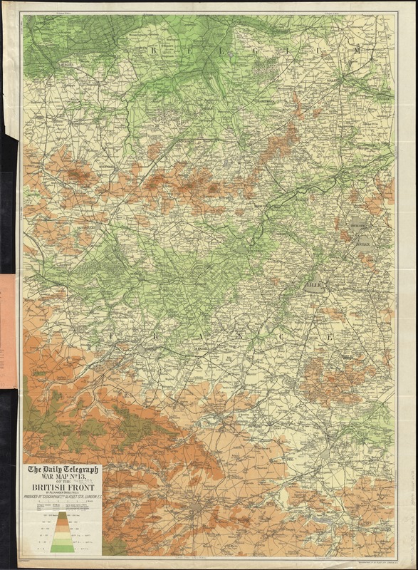
The Daily Telegraph war map no. 13 of the British front
Item Information
- Title:
- The Daily Telegraph war map no. 13 of the British front
- Title (alt.):
-
Daily Telegraph war map of the new British front in contour colouring (No. 13)
- Creator:
- Gross, Alexander, 1879-1958
- Name on Item:
-
by Alexander Gross, F.R.G.S ; produced by "Geographia" Ltd.
- Date:
-
[1916?]
- Format:
-
Maps/Atlases
- Location:
-
Boston Public Library
Norman B. Leventhal Map Center - Collection (local):
-
Norman B. Leventhal Map Center Collection
- Subjects:
-
World War, 1914-1918--France, Northern--Maps
World War, 1914-1918--Belgium--Maps
France, Northern--Maps
Belgium--Maps
- Places:
-
France
Belgium
- Extent:
- 1 map : color ; 97 x 67 cm, folded in cover 21 x 13 cm
- Terms of Use:
-
No known copyright restrictions.
No known restrictions on use.
- Publisher:
-
London :
"Geographia" Ltd.
- Scale:
-
Scale approximately 1:95,000
- Language:
-
English
- Notes:
-
Relief shown by gradient tints and spot heights.
Area: from Dixmude to Blaireville ; from Aire to Toufflers.
Shows place names, roads, railroads, approximate position of Allied Front prior to the Battle of the Somme.
- Identifier:
-
06_01_012054
- Call #:
-
G5701.S65 1915 .G76
- Barcode:
-
39999065692475