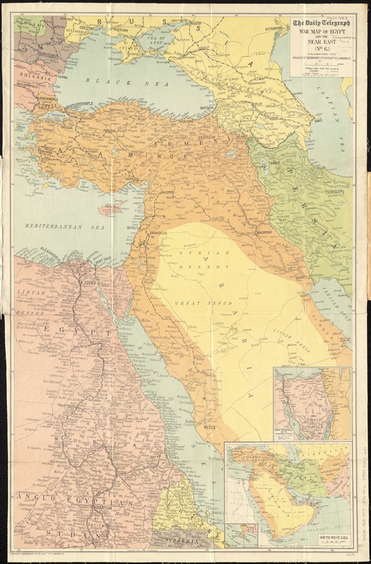
The Daily Telegraph war map of Egypt and the Near East (No. 6)
Item Information
- Title:
- The Daily Telegraph war map of Egypt and the Near East (No. 6)
- Title (uniform):
-
Daily telegraph (London, England)
- Creator:
- Gross, Alexander, 1879-1958
- Name on Item:
-
by Alexander Gross, F.R.G.S. ; produced by "Geographia" Ltd.
- Date:
-
[1916]
- Format:
-
Maps/Atlases
- Location:
-
Boston Public Library
Norman B. Leventhal Map Center - Collection (local):
-
Norman B. Leventhal Map Center Collection
- Subjects:
-
World War, 1914-1918--Middle East--Maps
World War, 1914-1918--Egypt--Maps
Egypt--Maps
Middle East--Maps
- Places:
-
Egypt
Middle East (area)
- Extent:
- 1 map : color ; 85 x 53 cm, folded in cover 21 x 13 cm
- Terms of Use:
-
No known copyright restrictions.
No known restrictions on use.
- Publisher:
-
London :
"Geographia" Ltd.
- Scale:
-
Scale approximately 1:4,500,000.
- Language:
-
English
- Notes:
-
Relief shown by hachures.
"Copyright Geographia Ltd., 55 Fleet Str., London, E.C."
Insets: Sinai peninsula and the surrounding countries -- South West Asia -- [Aden and Strip of Bab El Mandeb].
- Notes (date):
-
This date is inferred.
- Identifier:
-
06_01_012045
- Call #:
-
G5701.S65 1915 .G76
- Barcode:
-
39999065692681
- LCCN:
-
2013594035